Sunday, 23 June 2013

The City Hall clock

Guelph, like most Canadian cities, has featured a number of prominent city clocks. As Marc Boileau observes in his book "Towers of time" (2006), clocks were often regarded as public works, that is, as a service that the builder rendered to the citizenry. A centrally controlled clock could, in effect, broadcast the official time to everyone in the vicinity. This function was especially important before the development of standard time and time zones, when each city determined local time for itself.

In Guelph, the first civic clock was a sundial situated on the stump of a maple tree that John Galt and his party cut down to officially found the settlement. Of course, such an arrangement was neither durable nor equal to the dignity of the town as it grew from a clearing in the woods to a regional centre.

During 1856, a handsome city hall was built in the Market Square, at what is now 59 Carden St. Designed by the prolific architect William Thomas, the structure included a short dome with a clock. There are no postcards of this structure (postcards were introduced much later), but it is nicely visible in the 1867 photograph below.

(Courtesy of Leanne Piper)

The time is not legible, but two of the clock faces are visible just below the top of the dome. The placement of the clock at the utmost possible height suggests its official function, namely to broadcast the correct time throughout the area. At the same time, the placement also helps the building to play its role as the regulator of the community. The clock faces not only show the time, they also survey their surroundings almost as if they were real faces.

In 1869, this original tower was replaced by an even taller and more prominent one. Stewart (1976, vol. 1, p. 83) states that the old dome had begun to leak and needed attention. This issue seems to have given the people in charge a reason to increase the importance of their building even further. David Allen comments (1939/2012, p. 86):

We of today can only guess the reason for this alteration, but, for one thing, taller buildings began to arise in that section [of town], and the increased height would allow more freedom for sounds of the bell to float above them, and, then again, faces of the clock could be seen from a greater distance, as the new buildings surrounding obscured the view.
Buildings sometimes compete for prominence in height (height makes right?), and Guelph's City Hall seems to have been no exception.

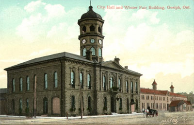
The City Hall with its new belfry is nicely displayed in this postcard from ca. 1900:
(Courtesy The City of Guelph)

The card is labelled "City Hall and Winter Fair Building, Guelph, Ont." and was published by Valentine & Sons. From what I can see by comparing this card with the photo above, it does not appear that the clock faces attained much more height as a result of incorporation into the new tower. However, the belfry is significantly higher, suggesting that Allen was right when he emphasized the sonic function of the new structure.

In any event, the entire tower was removed on August 8, 1961. Its absence is unlamented, as its assertive verticality seemed at odds with the horizontality of the rest of the structure, as noted in the Historic Places website:

Thomas placed a central, squat round clock tower on the roof that was replaced twice during subsequent years. Unfortunately these taller versions altered Thomas' thoughtful proportions and projected from the roof line at a rather obtrusive height. The tower was removed altogether in 1961.
Besides aesthetics, it may also be that no one could see any reason to maintain the tower when its clock and bell were no longer useful nor symbolic of the building's station in the civic order.

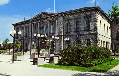
The post-tower appearance of City Hall is shown in this postcard from ca. 1970:
(Courtesy The City of Guelph)

All that remains is a scrawny, white flagpole.

Here is the Google Street View photo of the City Hall. It is a bit nasty since the site was under construction at the time.


View Larger Map

A better idea of the history of the City Hall, and its current condition, can be found at this very nice slideshow.

More on Guelph's civic clocks to come!

Sunday, 9 June 2013

Bowling for dollars!

I suspect that the the title of this post will have readers scratching their heads. What does "Bowling for dollars" (BFD) have to do with Guelph postcards? Let me explain, beginning with BFD itself.

As noted on its Wikipedia page, Bowling for dollars was an American game show where contestants would bowl to win prize money. It seems to have originated in the late 1960s, and reached its zenith in the mid 1970s. Each station that aired the show ran its own version, but the format was largely the same everywhere:

The show's main set consisted of a sliding door from which the host emerged, as did the contestants, one-by-one. There was also a Jackpot light with a numeric display of its value, and a Pin Pal hopper. There were also stands set up for an audience.
Each contestant was briefly interviewed by the host and would then point out their family in the audience before the game commenced. They would then bowl two balls, and receive a prize depending on the number of pins knocked down. There was extra money for strikes and spares, and a special Jackpot for any bowler who bowled two strikes in a row.

You can get the idea from this clip from the WTAE Pittsburgh station:


You may have noticed that, after the introductions, Lori opened a hopper filled with postcards. Viewers of the show were encouraged to send postcards identifying themselves to the station. Each week, the postcards received were placed in the hopper and each contestant would pick one out. The person named on the selected card was the "Pin Pal", who would win the same amount as the contestant. The postcards served to allow viewers at home to take part in the excitement.

Two postcards in my collection were used to enter Guelphites as Pin Pals. The first postcard has on its front a photo of picnickers enjoying Riverside Park.


On the back, the card is identified as a "Traveltime product", distributed by the "Kitchener News Co. Ltd.", using the Colurychrome process. The scene is labelled as "Silver Creek Park // Guelph, Ontario // Picnic and playground area". This is confusing because, today, Silvercreek Park comprises the banks of the Speed River in the city's downtown, near Edinburgh Road. In the early 1970s, however, it seems to have denoted the southern half of what is now Riverside Park in the north end. Or, perhaps the producer was confused.

In any event, the card is addressed to: "Pin Pal // WGR TV // Box 5000 Niagara Square Station // Buffalo NY // 14202." The addressee is identified as, "Mary Pratt // 33 Inverness Dr. // Guelph Ont." The postmark is too faint to read, but might be 1978 or 1979.

The second postcard has a photo of the old OAC Biology Building, where I believe the OVC Pathology Building now stands.


On the back, the card is identified by its logo as another Traveltime product from Kitchener. The scene is labelled as "Biology Building // Guelph University // Guelph, Ontario." The card is also addressed to "Pin Pal" at WGR TV, and the addressee is "Norm. Harrison // 4 Sunnylea Cres. // Ap. 1 // Guelph Ont. // Can." The postmark reads "3 VII, 1978".

I wonder if Mary or Norm won anything.

Evidently, Guelphites were treated to the Buffalo edition of the show, hosted by Ed Kilgore who, as it happens, just recently left WGRZ Buffalo after 40 years. Ed's picture was put in the announcement of the show at its inception, placed in the Toronto Star on December 26, 1972. Check it out.


Although the heyday of the show belongs now to the distant past, it is still fixed in the memories of many. It has, for example, become a paradigm for interactive entertainment, as noted here in the Guelph Mercury (Oct. 16, 2001):

Undaunted, their [the NHL's] recommendations include elimination of on-ice activities, restriction of fireworks and laser shows where smoke or mist is a no-no. This is directed at quality ice for the players.
It's obvious this means curtailing the popular, between periods, "bowling for dollars," the sling-shotting of humans down the length of the ice into giant inflatable pins. These people are randomly selected dopes who come out of the stands with the express purpose of winning pizza and nachos for their entire row of seats.
Also, it has become an activity useful for charity fundraising, as exemplified in this item from the Kitchener Post (June 14, 2012) in an article entitled "Bowling for Dollars":
The Kitchener Lawn Bowling Club is holding a special fundraising event on June 16 in support of St. Mary's General Hospital. Funds raised will be used to purchase a portable pulse oximetry machine for the hospital's sixth-floor chest unit.
All in good fun!

Never the most gripping of shows, BFD became a byword for tedious, crass, or low-brow entertainment among some observers. Here are some interesting mentions from the Toronto Star. The first is from Would you rather (a) sleep or (b) vote? (Gary Lautens; May 24, 1977):

During paid political announcements on TV that interrupt your favorite programs, do you (a) use the time for a trip to the washroom, (b) draw a moustache on your TV screen with magic marker, (c) switch to another channel in the hope of getting Bowling for Dollars, Polka Time, or a Tide commercial instead?
The second is from Without rock, it’s tepid TV (Margaret Daly; Feb. 16, 1979):
This show [the Grammy Awards] had more sequined tuxedos than a Liberace lookalike contest. The moments of victory had all the class and none of the spontaneity of Bowling for Dollars, and the musical numbers were performed with the vitality and vibrancy you might expect from a troupe of heroin addicts on the nod.
The last is from At least the news is relatively new (Jim Bawden; July 20, 1983):
Did somebody mention the word ‘reruns’? … How about a special called Bowling for Dollar’s Finest Strikes? Or The Best Hockey Slapshots of 1983? I fear TV programmers are about to unload these on us. Certainly, they’ve tried everything else.

Whatever your view of Bowling for Dollars, it was a bit of popular culture that reached Guelph and left a lasting impression. Plus, it seems to have sold a lot of postcards. How many more Pin Pal cards from Guelph are hidden away in the attics, drawers and albums of the region?

So, if you are a Guelphite who sent in a card—or just have fond memories of the show—post a comment and let us know!

Update (13 July 2013): I just picked up another postcard, also of the Biology Building, also sent to Pin Pals at WGR TV. The postmark is smudged but might be 1978. A good year for Pin Pals, it would seem! This one is from "Mrs. N. Stanley // 40 Derry St. // Guelph" and adds, "Knock them down for yourself and me. Good luck."

Friday, 24 May 2013

Central School

This postcard depicts the old Guelph Central School, as seen from the east at the intersection of Norfolk St. and Cambridge St. (now Commercial St.) The address of the school was 93 Dublin St., that street being in behind the building from the perspective of this postcard. It is unusual for postcards to show the back of a building, but there is an interesting reason for it in this case.


The postcard was made for A. L. Merrill, who had a stationary business in Toronto. As with many postcards of the era, it was colourized and printed in Germany. The postcard also has very explicit instructions to the user: "The address only to be written on this side", meaning the entire back of the card. The now-familiar divided-back format, in which a message was written on the left side of the back and the recipient's address on the right, became common after 1905. Probably, this card (and the photo in it) were made before that year. The card is postmarked Oct. 16, 1907, and was addressed to a Miss Eliza Beacock, Wolseley P.O., Ontario. It reads, "We got your letter safely & I am watching the mail every day & will come to the station to meet the train you say, with love to all." With the back wholly taken up with the address, only the small white space on the front was left for recording messages.

The card also provides another illustration of how postcards were often used to make quotidian arrangements in the Edwardian era.

Prior to the construction of the Central School, secondary public schooling in Guelph was held in "three or four rented rooms in the Guelph Cartage Company building, at the corner of Essex St. and Gordon" (Waugh 1961, vol. 1, no. 4). These accommodations had become too meager and, along with the need for more educated workers and Egerton's Ryerson's 1871 Education Act, the local Board of Education decided to build a new, larger school on the ridge of Dublin St., next to "Catholic Hill." The Board acquired the necessary properties, which included a slice of Cambridge St. which, according to the official survey, went straight over the ridge from Norfolk St. in the east to Yorkshire St. in the west. In fact, the ridge was much too steep for vehicles of the day, so no one was inconvenienced by having the street divided. In 1956, the short part of Cambridge St. in the foreground that connected with Norfolk was renamed as "Commercial St." (Irwin 2002).

The Toronto architectural firm of W. R. Strickland won the contract to design the school. Construction began in 1873 and finished in 1876. The Guelph Herald of 1876 gave the following description of the city's shiny new building (Pollard & Pollard 1981, "Guelph's building boom of 1875-76", pp. 70-73):

It is built of Guelph stone, the dimensions being 120 ft. in length and 86 ft. in width, four storeys in height, consisting of basement, ground and 1st floors and mansard storey; 9 ft. 14 ft. 13 ft. and 12 ft. in height respectively. The centre portion of the building breaks out from the line of the building 4 ft. and is carried up 10 feet higher in the centre than the surrounding parts, which gives relief to the structure and from the additional height affords space for a large assembly hall. The roof is of the French or Mansard style, covered with purple and green slate arranged in appropriate patterns, and the deck or flat portion of the roof is covered with tin, surrounded by a handsome railing. The slopes of the roof are pierced by dormer windows, by which the upper rooms are lighted, and by which the plain surface is relieved. ... The basement contains the caretaker's apartments, lunch rooms, fuel rooms and heating apparatus. Upon the ground and first floors are situated the class rooms, 16 in number, 8 on each flat, also the teachers' and apparatus rooms. The upper or Mansard storey contains the assembly hall and 4 ante rooms two on either side. ... The belfry stands 45 feet above the roof, terminating in a handsome wrought iron finial 12 feet in height, with weather vane, and scroll work with gilded points, &c. The belfry is octagonal in shape, with louvred ventilators, and is covered with galvanized iron on the sides, the roof being slated."
A broad staircase connected the back of the building with Cambridge (Commercial) St., although it seems to have been removed in favour of a more modest link by the time of the photo in the postcard.

As noted by Gilbert Stelter (1989, "Henry Langley and the making of Gothic Guelph"), there was a "profusion of spires" in city skylines around the English-speaking world at the time, as churches were built with tall spires in order to dominate their city skylines. The vertical thrust of the Central School, capped by its 45 ft. belfry, seems like a secular entry into that competition. The school, sited near the resplendent Church of Our Lady, and on the shoulder of the same drumlin, was designed not merely to provide room for Guelph's students, but also to stake out a slice of the city's horizon.

This gesture also explains why the school is pictured from the rear. It is the back of the school that looks out over downtown Guelph, while the front faces Dublin St., in the other direction. Downtown Guelph is where the attention was that the school building was meant to attract, so the building faced that way. Knowing this, the photographer took his picture from that vantage point.

Central School endured, with many changes, until the 1960s when it began to seem more-and-more behind the times. The belfry was removed about 1963 and the building demolished in 1968 (Anderson and Matheson 2000, p. 76). It was replaced by the modern Central Public School, with quite a different set of architectural priorities, as you can see from the photo below.


The new building is long and low, reflecting a priority on cost-efficiency, as it is cheaper to build along the ground than up in the air, at least when land is inexpensive. The low profile also probably makes it much more accessible than the old one. In addition, the building has firmly turned its back on the downtown core, with a fence to separate the yard from Commercial St. No doubt this measure is for security, to help limit the number of places where students and others can access the campus. A remnant staircase is still present on the side of the hill.

A much better view of the building is afforded at its front face on Dublin St., as you can see from this Street View image.


View Larger Map

Waugh (1961) records an interesting observation about the Guelph limestone used in the old building:

If you look carefully at the stone in the front of this building, you can see the imprints of sea animals.
You'll find no fossils embedded in the concrete of the new school. However, you will find a relic there: The bell from the old school was preserved and mounted beside the entrance of the new one. It is hard to make out in the Street View picture, but can be seen more plainly here.


The inscription on the bell reads, "The Jones & Company, Troy Bell Foundry, Troy N.Y., 1876." The plaque says, "CENTRAL SCHOOL BELL // This school bell was cast in Troy, New York, and was hung in in the original Central School on this site in 1876. It remained in use until the school was demolished in 1968. This plaque was presented to the Wellington County Board of Education by Craig, Zeidler & Strong Architects, September 1969."

What would the old bell say about its new perch, I wonder, if it could?

Tuesday, 14 May 2013

The Petrie Building

This postcard provides a view of Lower Wyndham St. looking from the southwest corner of Wyndham and Macdonell towards the northeast corner. It seems to have been taken from a fourth-floor location, which is interesting because the fourth floor of the Day's Block along Wyndham St. does not reach Macdonell, where the camera appears to have been placed. Either the photo was taken a little to the south, from a window in the King Edward Hotel of the time or, more daringly, it was taken from the roof of the three-story structure at the intersection.


Like the postcard of Park Avenue discussed here, this card was printed in Canada for C. Anderson and Co., Guelph, by Warwick Bro's & Rutter of Toronto. Charles Anderson had a book, stationary, china and fancy goods store at 53 Wyndham St. That would be in St. George's Square, up Wyndham St. and just around the corner (and out of view) on the right-hand (east) side in the photo. The photo must have been taken after the old Post Office in the Square got its third floor in 1903 but before the Square was renovated in 1908. So, let's say ca. 1905.

There are many things to enjoy about this photo. The level horizon of rooftops at eye height provides an interesting contrast with the strong diagonal of Wyndham St. below. The eagle-eye view also provides an element of voyeurism, as the viewer spies on the doings of folk in the streets, going about their business unaware of the viewer's gaze. The street is busy with a mixture of streetcars, horse-drawn conveyances, and people on foot, as was typical of the time. A couple of oddities are also visible: there appears to be some kind of cone on a post in the middle at the bottom, while a blurry horse and wagon appear in the lower-right corner, going too fast for the camera to capture clearly.

The photo also has a pleasant, warm sepia tone, although it is actually a halftone picture that has yellowed with age.

Compare the vantage provided by the rooftop with the view from below via Street View:


View Larger Map

For present purposes, the photo is also interesting because of the view of the Petrie Building that it provides. The Petrie Building is located near the right edge of the picture, immediately to the left of the Kelly Building on the corner, with its conical, mansard roof topped with iron crestwork. The Petrie Building, uniquely, is capped with a broken pediment, framing a giant pharmacist's mortar and pestle, in metal-covered wood (Couling 1996, p. 32). The Petrie Building is a Canada Historic site and is described in the register as follows:

The Petrie Building, designed by Guelph architect John Day, was completed in 1882 for Alexander Bain Petrie. Petrie was a local pharmacist and manufacturer, and one of the City's most successful and influential businessmen. Four-storeys high and constructed of stone and timber, it is one of a very few buildings remaining in Canada incorporating a stamped galvanized iron façade. This was a popular building technology of the late 1800s and was used as a substitute for wood, stone or cast iron. There are only three documented buildings in the country erected prior to 1890 with full sheet-metal facades, the other two being Victoria Hall in Hamilton and the Empire Hotel in Winnipeg. The galvanized iron facade was manufactured for Petrie by the Ohio firm of Bakewell and Mullins, specialists in architectural sheet metal working. Stylishly ornamented and elaborately embellished, the facade is distinguished by a bold cornice with a broken pediment framing a large mortar and pestle, a reminder of the building's original function as a pharmacy.
At the time, the Petrie Building's address was 15 Wyndham St., although it now has the address 53 Wyndham (the former address Anderson's store, where this postcard was sold, by coincidence).

Alexander Bains Petrie (1843–1921) was certainly a prominent member of the community and very active in community life. The obituary in the Guelph Evening Mercury (Sept. 24, on the front page) notes that he began his career by establishing a drug store in 1869 at the corner of Carden and Wyndham streets. He moved this to the "Petrie building" upon its completion in 1882. Besides its unusual facade, the building harbours some oddities of organization, such as a secret passage to its neighbour.

Robert Stewart provides a snapshot of Petrie's pharmaceutical business from an article in a Guelph newspaper from 1894 (1976, p. 147). The article lauds Petrie's building and his wares, of which it lists the following:

Sarsparilla, Blood Purifier, Dyspepsia Cure, Pectoral Balsam for Colds, Anti-bilious Pills, Sheep Dip, Worm Powders, Baking Powder, Cake Coloring, Flavoring Extracts, etc. etc.
Quite a collection! One can only hope that the various preparations did not get confused.

Petrie was also the founder of the Petrie Manufacturing Co., of Galt, Guelph, and Hamilton. In addition, he was the owner and founder of the Masonic block on Upper Wyndham, and the factory opposite the train station on Carden St. As you might have guessed, he was a Mason, and a founder of the Guelph and Ontario Investment and Savings Society, of which he was president for about 20 years. He was also a councillor in the South Ward (1874–1876) and an alderman for the later St. George's Ward (1897, 1901).

Wait, the indefatigable Petrie was not done yet! In 1894, he was a founder of the Guelph Road Race Association and, in 1898, built the Petrie Athletic Park on Gordon St., around where the current Guelph Lawn Bowling Club now stands by the Speed River. The facilities of the Park were impressive:

The provincial cycle races were held there in 1899, and the park soon featured a large range of events, skating carnivals, ice-shows and hockey games. It also offered an indoor bathing pool, gymnasium, tennis courts and a bowling green. On the night of February 28, 1900, the gymnasium was converted into an elegant ballroom for the assembly of the Victoria-OAC Hockey club. Thain’s orchestra played on the encircling balcony, and, after a break at midnight when the 175 invited guests served supper, continued until two in the morning. (p. 18)
A picture of Petrie and his facility are available here, while a perspective map of the complex is available here.

Since Petrie's death, the Petrie Building has passed through several hands, and it is currently owned by Agelakos family, who operate the Apollo 11 restaurant on the ground floor. As you can see from the Street View picture, the upper floors have sunk into decrepitude. However, a group called "Save the Petrie Building", led by local archaeologist David Knight, has been formed to try to have the building preserved and perhaps restored. The group has been featured in a Facebook Stories article, with a pointer to their Facebook page. Recently, the group also staged an art exhibit about the building to help raise public awareness.

Given his energy as a public figure in the city, I am sure that Petrie himself would appreciate the effort.

Wednesday, 1 May 2013

Laura Lemon

This postcard shows a view across the Speed River in downtown Guelph. As the label says, the house in the photo is the "Birthplace of Laura Lemon, Author of 'My Ain Folk', Guelph, Ontario, Canada 9."


The postcard was made by the Photogelatine Engraving Co., Limited, Ottawa, denoted by the acronym "PECO" in a maple leaf, as printed on the back of the card. I do not have much information about this company, but they produced many Canadian postcards, seemingly between 1920 and 1940. The picture also appears in a Valentine & Sons postcard, so it may have been taken in the Edwardian era.

A brief article in the "Historic Guelph" (vol. 2, no. 5) provides some interesting information. The house in the card was known as "Mavis Bank", and Laura was born there on Oct. 15, 1866. (Here is a photo of her.) In 1871, the family moved to a house called "Ashcote" on Queen St., where they entertained the Marquis of Dufferin, then Governor General of Canada, in 1874.

Clearly, the Lemons were a prominent family in the city. Her father was Andrew Lemon, Queen's Council, and a partner in the law firm "Lemon and Patterson". Her mother was Laura Armstrong, after whom she was evidently named. In 1873, Lemon St. on Eramosa Hill was named after Mr. Lemon (Irwin, 2008, p. 47). Unfortunately, he appears to have speculated in some railway venture and lost, prompting the family to move to Winnipeg in 1881.

Laura must have displayed musical talent early, as she travelled to London to study at the Royal Academy of Music in 1890. The article has this to say about her abilities:

Laura was a fine musician and her piano playing was really magnificent. She is said to have had the ability to make the piano sing. While many of her compositions are Scottish in theme or title, she never set foot in Scotland.
Laura seems to have enjoyed a successful career. Her big hit was "My Ain Folk" in 1904 (music here), along with "Slumber Songs" (1895), and "Three Moravian dances" (1910). Although she never returned to Canada, she did write patriotic songs about her home country, e.g., "Canada Ever!" (1907), "Mighty Dominion" (1910), and "Canadian Song Cycle" (1911).

The continuing popularity of "My Ain Folk" is apparent from a YouTube search, which turns up over 7,500 hits. Here is my favorite rendition:


Laura Lemon passed away on August 18, 1924, which may have prompted PECO to reproduce the card. It shows the Speed in summertime, with Mavis Bank in its verdant setting on the river's edge. Of special note are the trellis posts of the verandah, characteristic of Picturesque architecture in the second quarter of the nineteenth century. Today, the site lies across from the River Run Centre, so there is no Street View image that matches the photo. However, a similar view can be had from the Royal Recreation Trail along the riverside, as you can see here:


This photo was shot in April, 2013, with a lower water level. The greenery is not yet out, but the house and verandah are more visible that way.

Mavis Bank is now part of a three-residence complex, at 72–78 Arthur St., the front of which you can see in the Street View image below.


View Larger Map

Note the treillage on the verandah posts at the right, which maintains the type found on the structure when the postcard photo was taken and when Laura Lemon lived there.

Laura's songs were aimed at contemporary tastes and so have since faded from attention. However, the third Moravian Dance, "No. 3 Mazurka", has been included in a recent collection of Canadian works, Romance: Early Canadian chamber music (iTunes). So, enjoy! and think of Laura Lemon, one of the many Canadian musicians who left her old haunts and went abroad to make good on her career.

Tuesday, 23 April 2013

The Speed River

This postcard provides a picturesque view of the Speed River, the main waterway of the city. This seems an appropriate subject for a posting of Guelph postcards on the anniversary of its founding, that is, St. George's Day (23 April).


The text printed at the top of the face says, "No. 461 View on River Speed, Guelph, Canada". As far as I can tell, the expression "River Speed" was never common but was used in writing to lend a poetic air to the name. On the back, the card identifies itself as "Published by Stedman Bros., Brantford, Canada. Made in Germany." The postmark is dated May 26, 1908. Stedman Brothers were a leading publisher of postcards in Canada, as you can see from this little video.

Views of the Speed were popular subjects for postcards of the city. Postcard publishers and buyers liked views of "beauty spots", of which tree-lined rivers were a prime example. Guelph, founded on the banks of the Speed near its confluence with the Eramosa, is well endowed with such places.

This picture reveals how cities were viewed as places where elements of nature could be combined with, and domesticated by, man-made structures. On the right edge of the photo is the spire of St. George's Church on Woolwich St., that towers above the river. In the center of the picture is the old Heffernan St. footbridge that spans it. Both represent people's ability to civilize the wilderness without banishing it, an ability that Edwardian postcard images of Guelph often celebrated.

The city's relationship to the Speed River was central to its founding. One of the reasons why John Galt selected the site for his city was the presence of the river. The native American name for it is not recorded (to my knowledge), but Galt named it, apparently, for the force with which it flowed. A fast river promised plenty of energy to power the gristmills and sawmills that would drive Guelph's growth. Also, being an author with a romantic disposition, Galt simply liked a good river.

To be useful, the river had not only to be tapped but also bridged. The immediacy of this challenge is made clear in the "Annals of the town of Guelph" (p. 29):

For the remainder of the summer [of 1827], he [Mr. Strickland] was employed in superintending the erection of several houses, and in building two bridges, one over the Speed, and the other over the Eramosa branch. That over the Speed, where Allan's bridge now is, appears in a painting executed in the fall of 1828, to have been a very substantial and not inelegant structure, built on piles, the superstructure being partly of squared timbers. This was of great convenience to the settlers, as a good number of farms had been cleared on the other side of the river, and the farmers had hitherto been compelled to cross on a rude ferry, consisting of a raft of logs lashed together; and as the stream, especially in the Spring, was very swift, this was frequently attended with considerable labor and frequently also with some danger.
Though rafts can make for great sport, a sturdy bridge does sound much more convenient, and civilized.

The use of boats to cross the river did not cease entirely, however. The Rev. Arthur Palmer, rector of St. George's, used to commute to work by boat, as Florence Partridge notes in "Slopes of the Speed" (1992, p. 18):

During the time that Palmer lived in the Arthur Street house, there was no footbridge, so he kept a rowboat which he used to cross the Speed River to his church in St. George's Square. The original footbridge was built in 1881 to provide pedestrian access across the Speed River between Arthur Street north and Woolwich.
Too bad for Rev. Palmer that he had moved away by the time the footbridge was built!

Here is a Street View image resembling that of the postcard, taken from yet another bridge over the Speed:


View Larger Map

This photo was taken from the Eramosa Bridge, just a little upstream from St. George's Church. It displays roughly the same scene the postcard photo, although it shows the new, and higher, footbridge built in 1918 and the blank side wall of the River Run Centre. It seems likely that the postcard photo was taken from this bridge (or, more accurately, an earlier version of it). It is remarkable how much remains the same between the two images.

The postcard is addressed to "Miss Ida Fissette, Simcoe, Ont." and conveys this very charming message:

Think I will make up for lost time now & write to you nearly every day. I am homesick today. Can you wonder at it? Are you tired? Clare
Poor Clare! She does not say what brought her to Guelph, but many young women from the region came to the city at that time to study Home Economics and Domestic Science at the MacDonald Institute (now part of the University of Guelph). Doubtless, many felt homesick during their studies. I wonder if Clare found any solace walking in the city taking in the many views of the Speed.

Happy St. George's Day!

Thursday, 11 April 2013

Eramosa Rd.

This postcard presents a view of Eramosa Rd. (incorrectly labelled "Eramora Road") looking northward from the intersection of Eramosa, Woolwich St. and Upper Wyndham.


Text on the back of the card indicates that it was produced by "The International Stationary Co., Picton, Canada". It is one of a series of postcards of Guelph printed by the company, all done in this warm, sepia tone, with a narrow white frame and art-nouveau-font label on the front.

The photo clearly shows incandescent street lamps, directly above the hat of the woman in the foreground, that were introduced to downtown Guelph in 1912. The card is postmarked for June 1st, 1916, so the image can be dated to ca. 1915.

This card is one of my favourites. It is an unusual card in the sense that it is a professional card that has people in the foreground. Most professional cards of Guelph, at least in the Edwardian era, are of notable structures or places, less often of activities or events. Activity cards often feature people but focus on leisure or recreation, e.g., strolling in the park. Here, the ladies crossing Woolwich St. are in the foreground, but are not engaged in a recreation. Indeed, they are dressed in their fancy attire. So, what are they doing?

It is hard to be sure, but the photo offers some clues. Union Jacks and Ensigns are seen flying in the windows above (James) Steele's Wire Works (the building on the corner at the right margin of the photo). A line of Union Jacks and perhaps other flags is suspended across the road from Craven's Furniture to Trafalgar Square, opposite. (Henry Craven is listed as an upholsterer in the 1917 Vernon's City Directory, at 5 Trafalgar Square). In "Guelph: Take a look at us!", Donald Coulman provides a picture of the Dominion Day parade in downtown in 1912, noting that the buildings are covered in patriotic bunting (1977, n. 180). Dominion Day marked the establishment of Canada as a confederation and a British dominion on July 1st, 1867. (It is now known as Canada Day.) It could be that the ladies in the foreground are on their way to a Dominion Day celebration.

The background is also interesting. The Trafalgar Square road continues from the picture's center down to the Eramosa bridge. Eramosa then continues dramatically up and over the crest of Eramosa hill on its way out of town.

Things are happening along the roadway. A car appears to be turning off the road in the middle ground. Is it a Model T? Perhaps it is headed into the garage next to Craven's Furniture. Vernon's directory lists a "Maylor Auto Sales" at 9 Trafalgar Square, which seems likely to be the garage in the picture. The directory lists seven "garages" in total, suggesting that cars were becoming popular in the city, even at this relatively early date.

Further down the road, beside the furniture store, is a passenger rail car, apparently sitting on the Canadian Pacific Railway tracks next to the road. I gather that it is not going to cross the road since the white barrier poles on either side of the tracks are raised to permit traffic to cross.

Then comes the Eramosa bridge, spanning the Speed River. After the bridge, the colouration of the roadway seems to change, suggesting that the pavement ended there and that Eramosa road remained a dirt road at the time.

Although it is necessarily a snapshot, the picture provides an interesting tension. The three figures in the foreground approach the camera, walking with a purpose, even as Eramosa Road seems to lead the eye off in the opposite direction, away from the camera and over the horizon. Also, the different means of mobility, that is, walking, driving, and riding the train, remind the viewer about the places in the area outside of the frame of the picture. Retrospectively, the presence of the cars makes me think about how profoundly automotive traffic is about to change the city and the lives of the people in it.

Here is the current Street View image of the same vantage:


View Larger Map

Many of the details have changed. For example, the roadway has been widened, squeezing Trafalgar Square in order to accommodate more cars on Eramosa. The buildings on the right margin have been replaced by The Matrix Centre. Eramosa Road has replaced the "Trafalgar Square" address and now meets Woolwich St. However, the topology of the streets remains essentially the same.

The postcard was sent through the mail, so the back has some interesting things on it as well. First, it has a two-cent stamp, reflecting the fact that rates for postcards increased from one to two cents in 1915 for North American delivery. The text of the letter reads as follows:

Thurs. a.m.
Dear Margaret: Rec. your card. have the house-cleaning just about done. giving Ida a party on sat. after-noon. if Sid doesn't get off, you had better come up over sunday. Ida would like you to be here for her party.
With love from all
Grace and the boss
The receiving address is: "Mrs. S. Dudley, 88 Indian Grove, Toronto, Ont". I wonder if Margaret made it for the party. Or Sid. And, who was "the boss"?