Showing posts with label Speed river. Show all posts

Thursday, 25 July 2024

The early days of Orton

One of the main reasons that John Galt had for chosing the site he did for Guelph was the presence of the Speed River. The volume and energetic flow of water in the river could power many mills, which would be the mainstay of the town's economy, making it a natural centre for settlement in the region.

This fact makes it interesting for any scholar of the Royal City to consider the rest of the Speed River, especially upstream of Guelph. (The towns of Hespeler and Preston, downstream from Guelph, now part of the city of Cambridge, are perfectly interesting but lie in what is now Waterloo Region, and so are outside the purview of collectors of Wellington County ephemera, such as yours truly.) In that connection, the hamlet of Speedside has already been taken up in an earlier post.

What about the source of the Speed? Conventionally, this is traced to spot just outside of Orton, Ontario, a hamlet located at the edge of Wellington and Dufferin Counties, at the border of the townships of Erin and East Garafraxa. The Speed can be found beside the Elora Cataract rail trail just south of Orton, where it is a lovely but modest stream.

(The Speed river near the point where it emerges from under the rail trail at Orton. Photo by the author, July 2024.)

So, imagine my pleasure at obtaining a postcard of Orton, all the more so as postcards of little villages are often rare and hard to come by.

("Main St., Orton". Real photo postcard, ca. 1910. The view faces west from roughly the village's center.)

A railway crossing is visible in the immediate foreground, along with a few utility poles on the left-hand side of the street. These are likely telephone poles, which provided a service that was extended into the village in 1909. At the left margin is the facade of a general goods store, featuring a variety of items on the porch and a three-step gable. Unfortunately, the sign over the front awning is not quite legible. A cow is visible grazing on the grass on the right-hand side of street.

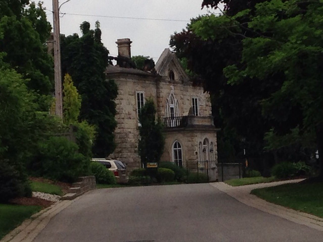
Here is a corresponding image of Orton today, courtesy of Google Street View:

The buidings once gathered around the railway crossing are notably absent today, not to mention the crossing itself.

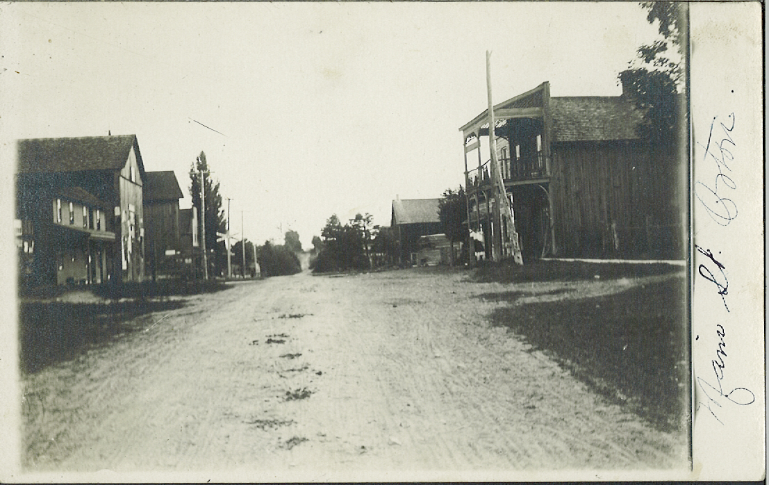
As luck would have it, the Dufferin County Museum has another postcard of Orton that records almost exactly the same view but taken from a slightly more westerly point along Main Street:

("Main Street, Orton". Real photo postcard, ca. 1910.)

The format, caption, and handwriting strongly suggest that this image was taken by the same person as the one above, just from a little further east along Main Street. A railway crossing "X" sign can be seen along the left side of the street, next to the store with the three-step gable. Across the road there is a building with a two-storey verandah; perhaps the hotel. The sign across a span of its second-floor balcony is not quite legible. At the bottom middle, fresh horse hoofprints can be seen in the road. Perhaps these were made by the horse that the photographer rode while passing through town.

(Corresponding image courtesy of Google Street View.)

A reverse angle photograph shows the street from the west side of the village looking east.

("Main Street, Orton, Erin Township, Ontario." Courtesy of Wellington County Museum and Archives, A1980.116.)

In this view, the two-storey hotel from the previous picture can be side on the left side of the street near the middle of the image. Utility poles are visible on both sides of the street in this picture, suggesting it was taken at a later time than the images above, perhaps in the 1930s after electricty arrived in Orton. Another building with a two-storey verandah can be seen in the right foreground. Unlike many of the old buildings in these pictures, this building remains standing today.

(Courtesy of Google Street View.)

As was the case with Gourock, the hamlet of Orton came into existence through an offical act of the Canada Post Office. The nucleus of the settlement was a small log house inhabited by John Glover, a farmer on the Garafraxa side. He and John Leeson, a farmer who owned the land on the Erin Township side of the line, sold off lots for houses and small businesses. One of the settlers to take advantage of this opportunity was William Mooney, who built himself a log house, 10x12 feet, on one of the lots. This, it appears, was a general goods store. Business was good and a larger store was later built on the site, with accommodations for the Mooney family provided on a second floor.

Mooney, his store and other enterprises are always noted as central to the story or Orton in the reminiscences of later residents. Of course, the store was a place where locals could find items that they were in need of but could also meet informally and chew the fat.

In addition to the store, Mooney was involved in the food trade, buying and selling local livestock, potatoes and turnips, and operating the local grain elevator. After his death on 12 July 1915, the Toronto World newspaper published a brief obituary (23 July 1915):

One of the founders of Orton is dead

The village of Orton loses one of its most respected citizens in the person of Wm. Mooney, who died suddenly on Wednesday of apoplexy, in his 64th year. He was one of the founders of the village, having erected the first general store, and in addition has conducted a general grain, live stock and farm produce business.
For 35 years he served as postmaster and was always foremost in his support of the interests of the village. The late Mr. Mooney was a Conservative in politics and a member of the Christ’s Church.
A widow, three sons and a daughter survive.
As noted, one of his accomplishments was the job of local Postmaster. Since 1840, the local post office had been located in the nearby village of Mimosa. However, everything changed when the Credit Valley Railway (CVR) came to town in 1879. The CVR connected the little hamlet with the Big Smoke, thus allowing Mooney to ship goods with much greater facility than before. No doubt, this linkage allowed Mooney to make connections in Toronto that were noted in his obituary. (The first passenger train left Orton on 19 February 1880. One can only imagine that Mooney was on it.)
("Canadian Pacific Railway station, Orton, 1898." Courtesy of Wellington County Museum and Archives, A2006.218. The CPR had taken over the CVR by this time. Apparently located on the north side of Main Street, the early station is not much more than a shed. Note the water tower in the background, positioned to supply water to the steam engines of locomotives.)

With a train station then right in town, it made sense for the mail to come by train along with people and goods. So, Mooney become the local postmaster in 1883 and set up a post office in his store. Naturally, the Post Office required a name for this branch. Up to this point, the community had been known, perhaps informally, as "Little Chicago." Brown (2006, p. 307) suggests that this name reflected a rivalry with the town of Grand Valley in Luther township, which was known locally as "Little Toronto."

("Canadian Pacific Railway station, Orton, 1911." Courtesy of Wellington County Museums, A2006.218. The new station was a significant upgrade from the original one. The station was later moved away and converted into a house.)

Whatever the case, the Post Office followed its established practice in such cases and blessed the locale with a new name, "Orton." This was in honor of Dr. George Turner Orton, who was then the Wellington-Centre Member of Parliament (1875–1887). Orton had been born in Guelph in 1837 and was educated as a medical doctor in back in the old country. In 1880, he was resident in nearby Fergus. Being a local bigwig, his name recommended itself to Post Office officials. What Orton thought of this distinction is not known. There is no evidence that he ever visted his eponymous community.

(Dr. George Turner Orton, M.P., Wellington Centre, Ont., 1879. Courtesy of Wikimedia Commons.)

In any event, the railway and the post office put Orton on the map.

The 1884 Ontario Gazeteer and Business Directory estimated the population of Orton at 50 souls and provides the following list of the hamlet's concerns:

Name Occupation
Hodgins, Wm. grocer
Lathorn & McLaughlin saw and shingle mill
Liddle, H. carpenter
Linsay & Clark grain dealers
Mooney, Wm. general store
Murphy, John hotel
Richings, F.W. live stock
Stevens, A shoemaker
Warden, L. blacksmith
Henry Liddle (usually spelled Henry Little) is the man usually credited with construction of Mooney's store and many of the other early buildings of Orton.

Another person listed in the directory who is often central in accounts of Orton is Lorenzo Warden (sometimes spelled Worden). Warden was born in Eramosa in 1851 and is listed as a blacksmith in nearby Ballinafad in 1876. Like Mooney, it seems that Warden saw the wisdom of relocating to Orton in its early days and set up as the village blacksmith, a business he kept up for most of the remainder of his life. (It appears he sold his business to the aptly named Fred Black around 1910 and moved to nearby Marsville but returned in 1911.)

A local blacksmith was vital to a rural community like Orton in that era. Transportation and mechanical power for farm operations was provided mainly by horses, and these had to be shoed regularly and properly.

Warden's son Osborn followed his father into the blacksmith's trade and took over the business for some time, followed by Harry Raven in the 1920s and William Lane. In a sign of the times, this building burned down and was replaced by a garage. Warden died on 9 December 1928.

Another founding father of Orton was John Near. Near was born in Erin in 1828 and the 1871 census lists him as a farmer in that locale, married to Ellen McEnery. He is also listed as a member of the Methodist New Connexion church, a splinter group of the Wesleyen Methodists who held with a high degree of equality between ministers and the laity. When what became Orton was first established, Near was the possessor of an extensive farm on the Garafraxa side of the line.

Today, Near is most remembered for his role in the construction of St. John's Methodist church in Orton. In her historical sketch of Orton, Mrs. Thomas Dearing (née Annie Collier) recalled (Acton Free Press, 27 January 1938):

Ever since the village was incorporated, the late John Near had agitated for a church to be built, so about the year 1900, in the midst of much opposition from the Grove Methodist Church adherents, he made arrangements for its erection, and putting all his time, labor and money into it, the church was completed, to his own satisfaction, and in 1901, the St. John’s Methodist Church was opened (St. John’s United now).
As noted in a Faded Genes blog post, there seems to have been some antagonism between Near and Mr. John Handley, the farmer who lived beside "The Grove" Methodist Church situated only two concessions east of Orton. Whether this antagonism was personal, doctrinal, or otherwise is unclear. In any event, Near convinced enough people to support the construction of a new church in Orton itself, St. John's.
("St. John's Church, Orton, Ontario." Photo by Gordon Couling, 18 September 1974. Courtesy of Wellington County Museum and Archives, A1985.110.)

The matter between churches persisted for some time, as the blog post goes on to describe:

And for many years there was some dissatisfaction in the community. Some of the people west of Orton continued to drive right through to The Grove Church; and others drove past the Old Church to the new one in Orton.
Whatever the issue, the result was that Near built a lovely stone church in Orton that graces the hamlet to this day. (The Grove church eventually closed and was demolished but its cemetery remains.) One item long remembered in connection with the church was that an entire ox was roasted on a spit over a bonfire at its opening. Admisson to the feast was 10 cents per person.
(Thomas Dearing, no date. Courtesy of Lorinda Mann.)

Besides the church, the formation of a local school was apparently a controversial item. In his reminiscence, Mr. Thomas Dearing recollected that a new school for the community was first discussed in 1887–88. A board of local dignitaries was formed to give the matter due consideration and a general meeting held at Orton (Acton Free Press, 27 January 1938):

A largely attended meeting was held in the Orton Hall to discuss the matter. Some hot words were spoken by some of the speakers, and hotly resented by the others, and some hard feelings caused, which was likely to break up the meeting, but Judge Drew, an excellent chairman, managed to keep order. There was no decision given at this meeting, but at a later one, it was decided to form a new section, with parts of 12 and 14 of Erin, and parts 4 and 8 of Garafraxa, to be known as the Union School No. 2. The first Trustees were Warren Jestin, Thos. Ballantine and John Near. The school was opened in 1892.
Judge Drew seems to refer to George Alexander Drew, a former Member of Parliament and then judge in the High Court of Justice for Ontario. It was no coincidence, then, that the judge was an old hand with contentious meetings.
("Exterior of Union School No.2, Orton, Erin Twp., ca.1891." Courtesy of Wellington County Museum and Archives, A1991.241.)
(Orton Public School today, now a private residence. Courtesy of Google Street View.)

Just what made the meeting so contentious is not recorded. Perhaps it was a consequence of the formation of Dufferin County ten years earlier, which separated East Garafraxa from Wellington County and produced the border that ran through Orton. In any event, the decision ultimately centered on the issues of the catchment area of the school and its location. These issues were sorted out and the Union School Section #2 was duly built on the townline road a short ways east of Orton. The trustees were John Near, Thomas Ballentine, and Warren Jestin.

It is usually mentioned that a Miss McKechnie became the school's first teacher in 1892 but remained in the job for only one year. However, she was not done with Orton, for she married Marriott McKee, one of the brothers who ran the McKee Bros. general store there. The marriage took place in 1899, by which time McKee had become a minister. The couple soon set out for British Columbia, where McKee would follow his vocation.

Beyond his essential role in founding the town church and his stewardship of the local school, Mrs. Dearing also gives John Near credit for building the hamlet's hotel, saying that he "forsaw the need of it in the community." Certainly, a local business entrepot like Orton would have use for a hotel. Grain and livestock buyers might choose to stay there while making purchases, and traveling salesmen would stay over while making calls on owners of local stores.

Mrs. Dearing notes that there had been many hotel keepers over the years, beginning with a Thomas Hodgin. (It may be that Near owned the hotel but let it to proprietors who ran the business.) The fullest description of the hotel is given in an undated history of Orton recorded by Alex Duncan:

One attraction at that time was the hotel, named the Exchange, owned by J. Irvine. It had a shed for farmers to tie teams in out of the rain or snow, and stable housing several driving horses to rent out to anyone who came in on the train and wanted to go out in the country. The usual fee would be about a dollar a day. Travellers used to come to the hotel and display their merchandise for storekeepers, and take orders instead of going to the stores.
As the local watering hole, the hotel was also the site of numerous goings on. The Grand Valley Star and Vidette provides the following example (23 March 1905):
Cost Him $22.85—Tom McLellan, of Orton, appeared before Magistrate John Carmichael of Hillsburg on Friday charged with disorderly conduct while seeking to gain entrance to North’s hotel during weesma’ hours a few nights previously. The coaxing methods by which he sought to soften the heart of the landlord were to try to break in the door and heave a six-pound dornick through the window. Squire Carmichael salted him $10 for breaking the law, $5 for breaking the window and door, and $7.85 for breaking into the time of the magistrate.
Clearly, running a hotel could be a trying business, which helps to explain why the hotel had several different keepers over the years. Indeed, North seems to have decided that he had had enough, and a new keeper came onto the scene in 1905, with a challenging vision for the establishment, as also noted in the Star and Vidette (19 October 1905):
A NEW VENTURE AT ORTON: John Gibson of the 10th line Garafraxa, who came home from British Columbia a couple of years ago in poor health, has rented the Orton hotel, and will conduct it on strict temperance principles.
How would the good people of Orton (and their visitors) respond to a hotel that did not serve alcohol? The Star and Vidette reported the following year on its success (5 May 1906):
He Couldn’t Do It—Mr. Gibson who has been running the hotel at Orton on strictly temperance lines for the past six months, has given up the business in despair.
Mr. Gibson returned to British Columbia the following year.

Other hotel keepers were more pragmatic on the subject, though some went perhaps a little too far, as the following item in the Acton Free Press suggests (19 November 1908):

Provincial License Inspector Ayearst secured convictions against William Willis, of Orton, in Erin Township, for which fines and costs amounted to $98. Willis was fined $50 and costs for selling liquor, and $40 and costs for keeping it.
Either Willis was not licensed or he sold liquor in ways that violated the limitations of the license he had. Nonetheless, William Willis is still listed as hotel keeper in the 1911 Ontario census. If there is a moral to this story, perhaps it is that, in popular watering holes, too much alcohol is viewed with more indulgence than too little.

The Great War profoundly affected Orton, as it did most Ontario communities. Several young men of the area went off to fight. The military careers of three of the Conlin boys provide a view into the variety of experiences the war afforded soldiers.

("Harry Conlin," no date. Courtesy of Dufferin County Museum, AR-2092.)

Three of Thomas and Elizabeth Conlin's boys went off to war. The first was Henry Ross, who joined up at Fergus on 16 December 1915 at 23 years of age, and was assigned to the 153rd Battalion. He married Mae Jessie McQuarrie of Fergus on 4 November 1916. He sailed to France on the RMS Olympic the following year and joined the 18th Battalion. Conlin seems to have done well and was promoted to corporal in August 1918 and then acting Sergeant. He lived to see the Armistice of 11 November 1918 but came down with the Spanish flu a few days later. He died on 29 November and was awarded the Military Medal posthumously.

("Willard Conlin, no date." Courtesy of Dufferin County Museum, AR-2092.)

Willard Conlin joined up, also at Fergus, on 8 January 1916 at 19 years of age. He trained with the 153rd Battaltion with his brother and was on the same ship with him, the RMS Olympic, when she sailed for Britain on 28 April 1917. He also served in the 18th Battalion. He was shot through the right knee near Arras on 26 August 1918, during the Hundred Days Offensive, when, after fierce fighting, the Allies pushed the German Army into retreat and finally the Armistice. Luckily, the wound was relatively benign and he recovered well. His military file even has a dandy x-ray of the affected joint!

Still, Willard fell ill from the Spanish flu in hospital but recovered. In January 1918, he got a case of the German measles (Rubella) but finally recovered from that also by the end of the year. All things considered, Willard was quite lucky to survive. He returned to Canada on the RMS Aquitania and was demobilized on 27 May 1919.

Willard returned to the family farm for a few years. On 24 September 1923, he married Florence Luella Johnston of Elora and the couple moved to Fergus. Willard opened a Ford garage/dealership and also served as a city councillor.

("Pte Franklin Conlin in uniform, 1920." Courtesy of Dufferin County Museum, P-2616A.)

The final Conlin brother to enter the service was Franklin, though he did not go voluntarily. He was drafted under the controversial Military Service Act on 10 May 1918, at the age of 23. He shipped out to Britain on the SS Corsican on 20 August 1918 and joined his unit in the field in France on 16 November, just five days after the Armistice. In March 1919, he sailed back to Canada on the RMS Carmania. He returned to the family farm and ran it after his father's death in 1926.

As Wellington County historian Stephen Thorning (2009) pointed out, the heyday of early Orton was the first quarter of the 20th century. Its population climbed over 100 souls and its railway station was an important shipping point for local stock and produce. Jim Courtney set up a turnip waxing plant in the grain elevator that was retired after the grain business moved west in the early years of the century. He also did a good business in potatoes and was the village barber as well.

Like Eden Mills, Orton also became a police village, in 1907. This designation allowed the community to set up some provisions for its own security, including fire-fighting, and enabled it to pave its main street, which was the dirt-surfaced townline. (This status was given up 60 years later when the village decided it did not have sufficient funds to maintain the main street, which reverted to control of Wellington and Dufferin Counties.)

In fact, government projects to pave the province's roadways and the increasing popularity and affordability of gas-powered vehicles also undermined the village's railway. Stock dealers from Hogtown could simply pick up cattle in trucks directly from local farms and ship them to stockyards in the big city. Uptake of cars and trucks meant that farmers could drive to Fergus, Guelph, or Orangeville for goods and supplies, bypassing Orton merchants. The advent of rural mail delivery also lessened the importance of the post office.

The local hotel fell victim to prohibition resulting from the Ontario Temperance Act of 1916, and the local bank branch closed in 1932.

As with many small, Ontario communities, these events and the Great Depression were a watershed moment that brought many changes. Electricity arrived from Niagara Falls in 1932, courtesy of the Hydro-Electric Power Commission of Ontario (also known as "Hydro"). The activism of Rev. A.L. Atton of St. John's church brought about a village park complete with baseball diamond and outdoor ice rink. More recently, Orton acquired a suburban street in the form of Elizabeth Crescent, which increased the hamlet's population to new heights.

Of course, closure of the railway line made possible the Elora Cataract Rail Trail, that hikers and cyclists can use to visit Orton, ponder the remaining old buildings and, if they so choose, locate the Speed River near its source.


Works consulted include:

Saturday, 26 July 2014

The Homewood Retreat grounds

Currently known as the "Homewood Health Centre", Guelph's place of refuge for the afflicted and addicted began as the Homewood Retreat on 18 May 1883. The Retreat was the first wholly, privately owned sanitarium in Canada. The prime movers of its establishment were A. J. W. Langmuir and E. A. Meredith, both of whom were former inspectors of asylums in the Province of Ontario.

They were motivated by both humanitarian and commercial interests. Langmuir thought that a private institution might be able to enact reforms in the care of patients that were not practicable in government institutions (Sanitarium 1983). At the same time, Canadian patients who sought a higher level of comfort and service were traveling to the United States for care. A local institution would keep that revenue in the country and make a profit for the shareholders (Hurd et al., 1917).

Finding a suitable location was crucial to the success of the venture (Sanitarium 1983, p. 1):

[Langmuir] conceived the idea of a private psychiatric hospital, preferably outside of the pressurized life of the big city of Toronto, yet near enough to be accessible by railway or road for horse-drawn vehicles.
Toronto, apparently, was not a good place for people to find rest and recovery. Besides which, land would be more affordable out in the countryside.

However they did it, Langmuir and his associates located an ideal site about one mile north of the centre of Guelph. The 19-acre property epitomized the ideals of the Picturesque. It contained the crest of one of the city's many drumlins, one that commanded an excellent view of the Speed River. In addition, a large and romantic residence sat along the hilltop. This house was "Craiganour", the former home of Donald Guthrie, once the local Member of Parliament, who named it after his birthplace in Scotland.

Craiganour was made of local stone and built in the Italianate idiom then very popular in the country. Notable features include the paired windows with rounded heads, the belvedere in the projecting tower and the broad awning over the porch that stretched around two sides of the structure. The effect was meant to be impressive but, at the same time, inviting. It is a great shame that it was destroyed by an electrical fire in January 1911.

The old building can be seen in the following postcard printed by Rumsey & Co., ca. 1910.


Although the building dominates the photograph, it is the grounds that are the centre of attention. The broad lawn is impressively flat, an observation reinforced by the substantial roller in the middle. Several figures are seen at the edges of the lawn, perhaps preparing to play tennis or croquet. To the left, a stairway can be seen connecting the lawn with the main building.

The site and grounds proved helpful in the rehabilitation of patients. Clearly, outdoor recreation was an important part of the therapy. A report on the facility in the Toronto Globe mentions lawn tennis and quoiting ("The Homewood Retreat at Guelph described," 27 April 1901). The Industrial Number of the Mercury also mentions "cricket creases" (1908). In addition, there are photographs of patients playing bowls on the broad lawns (Sanitarium 1983, p. 18). In fact, a game of bowls on the lawn appears in another postcard, this one published by the International Stationary Co. of Picton also around 1910.


One thing that I enjoy about many of the postcards from this publisher is that people are integral to the photographs. (Look through previous postings to see other examples.) Here, interest in the scene consists of the postures and arrangements of the people in it. Several men sit at their ease in stick furniture while others stand about apparently discussing the play. One lies recumbent on the ground to one side, echoing the posture of the chair in the middle foreground. It is a quiet and even indolent moment.

Besides gaming and sporting possibilities, the grounds offered opportunities for the simple enjoyment of water and greenery. Visitors never failed to notice the beauty of the site and its therapeutic potential. A Globe article on the opening of the institution describes them thus ("The Homewood Retreat", 31 May 1884):

On each [patient's] flat is an alcove with large bay windows facing south, so as to receive the sun for the greater part of the day. From these windows the prospect is a delightful one. The greater part of the twenty-acre park surrounding the building spreads out in front, stretching down to the River Speed, which forms the southern boundary. Glinting patches of the river's surface are seen, changing always as the gently moving leaves close or broaden the view. Dazzled with the brightness, the eye seeks relief and finds it in the sunny or shaded green of the grove, lawn, and meadow.
...
A ramble in the grounds was almost a day's outing. The trees are all strong and beautiful and the grass close and of healthy growth. At the rear of the house are the vegetable garden and orchard, also the stable and stable-yard.
There is one postcard that may capture a view of the Speed near this place. It is labelled simply "River Speed" and was published by Valentine & Son’s sometime around 1905.


The course of the Speed and the shape of the hill opposite are appropriate for a photo taken from the Riverslea estate, built originally by James Goldie and now on the Homewood grounds a little south of the original Homewood. The vista from the belvedere at the Homewood Manor might have been similar.

Another interesting description was given in a letter sent by "Veronica" to a column called "Circle of Young Canada" in the Globe (1 April 1916). In the letter, Veronica describes the scenery where she lives in Guelph:

I'm sure you'd all admire the view from our front windows. I'm not a very good painter of pen-pictures, or any other kind for that matter, but will try to describe it to you. Our house is at the head of a little street that runs down to the River Speed, so we have a clear view of that stream. The other side of the river is closely wooded and the trees were a picture when they were turning all colors. The Homewood Sanitarium is on top of the hill, and every day as the leaves fall we discover new buildings that couldn't be seen before. One of the buildings is called "The Manor" and looks just like an old English home situated in a large park. The scenery all around is beautiful also as there are hills in every direction, either wooded or laid out as farms.
Perhaps Veronica lived near the intersection of Strange (now Dufferin) St. and Clarke St., which affords a decent view of Homewood from across the river.

Besides surveying the Homewood grounds from her window, it may be that Veronica could have explored them readily on foot. A foot bridge had been built across the Speed for the use of patients to get to Homewood from the C.P.R. line on the other side of the river (Sanitarium 1983, p. 8). It was used as such by a special delegation from the Canadian Medical Association in 1910, who were entertained with a buffet luncheon on the lawns.

(This bridge was swept away in the flood of 1912, and it is unclear whether or not it was rebuilt. There is also mention of a foot bridge near Riverslea that existed "within memory of some older Homewood employees" but was removed due to decrepitude; Sanitarium 1983, p. 8).

The Homewood grounds continue to be an important part of the facility and of the greater community. It is, for example, the site of a "horticultural therapy program". Patients learn how to plant and maintain a vegetable garden, which is therapeutic in itself and brings them outside where they can enjoy their surroundings ("Homewood garden part of food production project", Mercury, 16 July 2014):

Currently the garden grows on a roughly 190-square-metre piece of land, surrounded by the centre's beautiful lawns, woods, trails, and historic buildings.

[Program director Tami] Proctor said patients started all of the garden plants from seed and transplanted the seedlings just over a month ago. "It's a true seed-to-table garden," she said.

"This teaches people how to plant a garden," she said. "Some have never planted before, and it gives those with gardening experience the opportunity to really shine and share what they know."

A garden, she said, acts as a "grounding tool," helping patients reconnect with nature, with their senses, and with a sense of inner peace. Digging in the dirt, hearing the surrounding sounds, engaging the sense of smell and taste, is all therapeutic.
The idea is reminiscent of the original idea for the Guelph Correctional Centre, in which prisoners were to be given agricultural tasks to perform in order to detach them from their fondness for alcohol.

Unfortunately, the future of the Homewood grounds may be in question. The current owner, Schlegel Health Care Inc., has applied to the city to sever a number of the lots on the property ("Committee of Adjustment", 12 June 2014). Although no permissions have been granted, it may be that some of the Homewood estate is headed for the auction block. Whether or not that would be a good thing remains unclear, but it would change fundamentally the character of that well-trodden terrain.


26 April 2016:
Schlegel's plans for Homewood portend big changes for the site, or sites. See the Friends of Homewood Grounds website for more information.

Also, see rych mill's Flash from the Past column for more history of the site and institution.

Tuesday, 10 June 2014

Wells' bridge

In the early morning hours of 13 May 2014, lightning struck the old manor at 25 Manor Park Crescent in Guelph. The old stone home caught fire, requiring the efforts of five city fire stations to extinguish. Witnesses described the conflagration as "fierce."

As noted in the Mercury article, the old Manor was built ca. 1857 for Arthur Wells (1824–1900), in the midst of his property just south of the Speed River, west of Edinburgh Rd. In those days, the location was known to locals as "Wells' Grove" and was considered to be at the very western edge of town at the time. Perhaps having property at the edge of town allowed Arthur and his wife Georgina Dora (née Rideout) to have a house and property of the grandeur they preferred.


As you can see below, the house is indeed striking. Gordon Couling (1976, v. 16) notes that it was probably designed by Wells and built by noted local mason Matthew Bell. Couling describes it as, "One of the finest stone homes in the city - of major architectural significance," and made from "limestone quarried on the property." Fire damage to the roof over the front gable is clearly evident.


In addition, pictures of the house are available at the Public Library Archive (here also), and the Wellington County Museum and Archives. The Library also has a portrait of Arthur, Georgina, and the family taken at the Grove ca. 1870. (The photo seems to show all eleven of their children and the youngest, Ralph, was born in 1866.) Plus, the Guelph Civic Museum has a photo of the stone barns that also sat on the property. The Wells family lived in style.

The story of Arthur Wells is related in some detail by a descendant, Jane Wells with Kathryn Bassett. Arthur was born and raised in Toronto and went to Upper Canada College. At the age of fifteen, he journeyed to Avignon in the South of France to study civil engineering at the University there. After graduation, he worked on building railway bridges in France and then returned to Canada to work on bridge building for the Grand Trunk Railway.

That work brought Arthur to Guelph where he supervised building of railway bridges at Rockwood and Guelph, at Allan's Dam. He must have liked the place as he settled in the town with Georgina and worked in various capacities, such as Deputy Postmaster, for a number of years. To all appearances, the family were upstanding citizens.

Then, in 1880, (proverbial) lightning struck the household. Arthur ran off with his housekeeper, Martha Glover. Stephen Thorning says that Wells experienced "a serious case of mid-life crisis" (Wellington Advertiser, 23 March 2007) and, indeed, Glover may have been pregnant when the pair left Guelph for Pueblo, Colorado. There, Arthur married Martha and the couple had a family of eight children in the United States.

Wells' Grove and Manor does not feature in any postcards of Guelph that I am aware of. However, the bridge over the Speed nearby at Edinburgh Road had become known as "Wells' bridge" and is labelled as such in the card below. This card was published by Warwick Bro’s & Rutter of Toronto, probably ca. 1905. (On some printings, the bridge is mislabeled as Gow's bridge, which stands further upstream.)


In those days, the Speed River flowed in not one but three channels at Edinburgh Road. Or, to put it another way, there were two large islands in the Speed at that time, requiring three bridges to span the gaps. (See this later aerial photo where the bridges are at the bottom centre.) The bridge in the postcard seems to be the three-span middle bridge, as seen roughly from the west. Look at this photo from 1928 for a similar view. Note that the Spring Bank Brewery, built by Sleeman's in 1900, is not visible in the postcard image, suggesting that it was taken before the turn of the century.

It is not clear how or when exactly Wells' name became associated with the bridge. Although Wells was a bridge builder, there is no mention of his having constructed this span. Also, since Edinburgh road itself was designated by the Canada Company in 1828 (Ross 1998), it seems likely that the structure preceded Wells' arrival in town.

The earliest use of the term "Wells' bridge" that I am aware of is in the 19 April 1869 Mercury, in which it is noted that "Wells' bridge" remained "uninjured" by a spring flood that year. Perhaps the bridge became associated with Wells because he took a special interest in it. For example, on 20 August 1867, he sent a report to the Town Council stating that the span was in a "dangerous condition" and should be open only to foot traffic until it could be repaired. It may be that this report cemented the association between Wells and the bridge in the minds of the townsfolk.

In any event, one certain connection between Arthur Wells and Wells' bridge is matrimonial misadventure, for the bridge was the site of a kidnapping and forced marriage. On 25 July 1877, Miss Annie Mary Carr, a niece of Sheriff Peter Gow, received a letter, apparently from her father stating that he would be in town the next day and asking her to meet him at Wells' bridge (Mercury, 30 July 1877 ff). She complied.

Instead of her father, however, she was met by a carriage with three men who said that they had been sent to pick her up. Unsuspecting, she climbed in and was taken to the corner of Wellington and Gordon streets where the carriage was met by Frederick Sturdy, a local painter and the man with whom she had recently broken off an engagement! He and his daughter Louise pushed her into the back of the carriage and ordered her to be quiet. The carriage proceeded out of town by Victoria road and south to Hamilton, where Miss Carr was confined in a house in a secluded location. Plied with alcohol and threats, Miss Carr agreed to marry Sturdy, the ceremony being quickly performed at the residence of the Rev. D. H. Fletcher, who seems to have suspected nothing.

It seems, though, that Miss Carr was missed and Sturdy suspected. Two constables from Guelph were sent to Hamilton on Saturday to investigate. They located Sturdy's carriage at the American Hotel there. Although Sturdy's whereabouts were not known, he had left instructions to prepare his horses for Sunday afternoon at five o'clock, so the constables decided to wait him out. Sheriff Gow arrived at 4pm and the three of them arrested Sturdy when he turned up. Upon finding out the location of Sturdy's hideout—104 Locomotive St.—Gow drove out and rescued his niece. She was returned to Guelph, and Sturdy and his daughter (and Sturdy's other assistants) were brought there to prison to await trial.

The sensational story was evidently picked up by newspapers around the continent, even as far as the Feliciana Sentinel of St. Francisville, Louisiana (25 August 1877). The Mercury described the abduction and forced marriage as "one of the blackest crimes ever committed in Guelph" and a deed that,

... would make the blood of all respectable citizens boil over with righteous indignation, and at the same time ask the question, "Can such an outrage have been committed in a civilized community?"
Despite the infamy of the abduction, it is not recalled in later histories of the town, much like Wells' flight to Colorado with his housekeeper. Perhaps both were tales too painful to repeat.

In any event, Wells' bridge remained in continuous use for 100 years or more. By the 1950s, however, the City of Guelph and the Grand River Conservation Authority had decided on some major alternations to the Speed River downtown. The City wanted to widen the bridge at Edinburgh Road to increase the flow of cars. This improvement to Edinburgh would also help with plans for a major new road along the riverfront ("Memorial Parkway", now Wellington Road). The Conservation Authority sought likewise to increase the flow of water in the Speed and thus reduce the perennial risk of flood along its banks.

In 1957, contractors dredged out the middle channel of the Speed, widening and straightening it like a highway. The overburden was used to fill in the north and south channels of the river, where Wellington Road and the Royal Recreation Trails now lie (Mercury, 23 Feb. 1956; 18 July 1957). Mostly likely, the rubble from Wells' bridge lies buried there too, along with whatever other tales it might have had to tell.

Wednesday, 1 May 2013

Laura Lemon

This postcard shows a view across the Speed River in downtown Guelph. As the label says, the house in the photo is the "Birthplace of Laura Lemon, Author of 'My Ain Folk', Guelph, Ontario, Canada 9."


The postcard was made by the Photogelatine Engraving Co., Limited, Ottawa, denoted by the acronym "PECO" in a maple leaf, as printed on the back of the card. I do not have much information about this company, but they produced many Canadian postcards, seemingly between 1920 and 1940. The picture also appears in a Valentine & Sons postcard, so it may have been taken in the Edwardian era.

A brief article in the "Historic Guelph" (vol. 2, no. 5) provides some interesting information. The house in the card was known as "Mavis Bank", and Laura was born there on Oct. 15, 1866. (Here is a photo of her.) In 1871, the family moved to a house called "Ashcote" on Queen St., where they entertained the Marquis of Dufferin, then Governor General of Canada, in 1874.

Clearly, the Lemons were a prominent family in the city. Her father was Andrew Lemon, Queen's Council, and a partner in the law firm "Lemon and Patterson". Her mother was Laura Armstrong, after whom she was evidently named. In 1873, Lemon St. on Eramosa Hill was named after Mr. Lemon (Irwin, 2008, p. 47). Unfortunately, he appears to have speculated in some railway venture and lost, prompting the family to move to Winnipeg in 1881.

Laura must have displayed musical talent early, as she travelled to London to study at the Royal Academy of Music in 1890. The article has this to say about her abilities:

Laura was a fine musician and her piano playing was really magnificent. She is said to have had the ability to make the piano sing. While many of her compositions are Scottish in theme or title, she never set foot in Scotland.
Laura seems to have enjoyed a successful career. Her big hit was "My Ain Folk" in 1904 (music here), along with "Slumber Songs" (1895), and "Three Moravian dances" (1910). Although she never returned to Canada, she did write patriotic songs about her home country, e.g., "Canada Ever!" (1907), "Mighty Dominion" (1910), and "Canadian Song Cycle" (1911).

The continuing popularity of "My Ain Folk" is apparent from a YouTube search, which turns up over 7,500 hits. Here is my favorite rendition:


Laura Lemon passed away on August 18, 1924, which may have prompted PECO to reproduce the card. It shows the Speed in summertime, with Mavis Bank in its verdant setting on the river's edge. Of special note are the trellis posts of the verandah, characteristic of Picturesque architecture in the second quarter of the nineteenth century. Today, the site lies across from the River Run Centre, so there is no Street View image that matches the photo. However, a similar view can be had from the Royal Recreation Trail along the riverside, as you can see here:


This photo was shot in April, 2013, with a lower water level. The greenery is not yet out, but the house and verandah are more visible that way.

Mavis Bank is now part of a three-residence complex, at 72–78 Arthur St., the front of which you can see in the Street View image below.


View Larger Map

Note the treillage on the verandah posts at the right, which maintains the type found on the structure when the postcard photo was taken and when Laura Lemon lived there.

Laura's songs were aimed at contemporary tastes and so have since faded from attention. However, the third Moravian Dance, "No. 3 Mazurka", has been included in a recent collection of Canadian works, Romance: Early Canadian chamber music (iTunes). So, enjoy! and think of Laura Lemon, one of the many Canadian musicians who left her old haunts and went abroad to make good on her career.

Tuesday, 23 April 2013

The Speed River

This postcard provides a picturesque view of the Speed River, the main waterway of the city. This seems an appropriate subject for a posting of Guelph postcards on the anniversary of its founding, that is, St. George's Day (23 April).


The text printed at the top of the face says, "No. 461 View on River Speed, Guelph, Canada". As far as I can tell, the expression "River Speed" was never common but was used in writing to lend a poetic air to the name. On the back, the card identifies itself as "Published by Stedman Bros., Brantford, Canada. Made in Germany." The postmark is dated May 26, 1908. Stedman Brothers were a leading publisher of postcards in Canada, as you can see from this little video.

Views of the Speed were popular subjects for postcards of the city. Postcard publishers and buyers liked views of "beauty spots", of which tree-lined rivers were a prime example. Guelph, founded on the banks of the Speed near its confluence with the Eramosa, is well endowed with such places.

This picture reveals how cities were viewed as places where elements of nature could be combined with, and domesticated by, man-made structures. On the right edge of the photo is the spire of St. George's Church on Woolwich St., that towers above the river. In the center of the picture is the old Heffernan St. footbridge that spans it. Both represent people's ability to civilize the wilderness without banishing it, an ability that Edwardian postcard images of Guelph often celebrated.

The city's relationship to the Speed River was central to its founding. One of the reasons why John Galt selected the site for his city was the presence of the river. The native American name for it is not recorded (to my knowledge), but Galt named it, apparently, for the force with which it flowed. A fast river promised plenty of energy to power the gristmills and sawmills that would drive Guelph's growth. Also, being an author with a romantic disposition, Galt simply liked a good river.

To be useful, the river had not only to be tapped but also bridged. The immediacy of this challenge is made clear in the "Annals of the town of Guelph" (p. 29):

For the remainder of the summer [of 1827], he [Mr. Strickland] was employed in superintending the erection of several houses, and in building two bridges, one over the Speed, and the other over the Eramosa branch. That over the Speed, where Allan's bridge now is, appears in a painting executed in the fall of 1828, to have been a very substantial and not inelegant structure, built on piles, the superstructure being partly of squared timbers. This was of great convenience to the settlers, as a good number of farms had been cleared on the other side of the river, and the farmers had hitherto been compelled to cross on a rude ferry, consisting of a raft of logs lashed together; and as the stream, especially in the Spring, was very swift, this was frequently attended with considerable labor and frequently also with some danger.
Though rafts can make for great sport, a sturdy bridge does sound much more convenient, and civilized.

The use of boats to cross the river did not cease entirely, however. The Rev. Arthur Palmer, rector of St. George's, used to commute to work by boat, as Florence Partridge notes in "Slopes of the Speed" (1992, p. 18):

During the time that Palmer lived in the Arthur Street house, there was no footbridge, so he kept a rowboat which he used to cross the Speed River to his church in St. George's Square. The original footbridge was built in 1881 to provide pedestrian access across the Speed River between Arthur Street north and Woolwich.
Too bad for Rev. Palmer that he had moved away by the time the footbridge was built!

Here is a Street View image resembling that of the postcard, taken from yet another bridge over the Speed:


View Larger Map

This photo was taken from the Eramosa Bridge, just a little upstream from St. George's Church. It displays roughly the same scene the postcard photo, although it shows the new, and higher, footbridge built in 1918 and the blank side wall of the River Run Centre. It seems likely that the postcard photo was taken from this bridge (or, more accurately, an earlier version of it). It is remarkable how much remains the same between the two images.

The postcard is addressed to "Miss Ida Fissette, Simcoe, Ont." and conveys this very charming message:

Think I will make up for lost time now & write to you nearly every day. I am homesick today. Can you wonder at it? Are you tired? Clare
Poor Clare! She does not say what brought her to Guelph, but many young women from the region came to the city at that time to study Home Economics and Domestic Science at the MacDonald Institute (now part of the University of Guelph). Doubtless, many felt homesick during their studies. I wonder if Clare found any solace walking in the city taking in the many views of the Speed.

Happy St. George's Day!

Wednesday, 6 March 2013

The Priory

Here is a postcard of what is arguably Guelph's most historic structure, namely "The Priory".  Also, it seems to have been Guelph's most popular early postcard subject, to judge from the number of different printers that used this photo and colourized it in different ways (more on that topic another time).


The back of the card has the title "Private Post Card" but no maker is listed.  The text in the lower, left-hand corner says, "First house in Guelph (now C.P.R. station), Guelph, Ontario."

The Priory was the first permanent structure built in Guelph, after its founding on St. George's Day, April 23rd, 1827.  The structure got its name from its builder, Charles Prior, who was one of the party that accompanied John Galt, the founder, to the site where the city was to be located.  It was intended to be the residence of the Canada Company officers in the district, and so had to be of a dignified appearance.  Thus, Galt saw to its design and construction himself, as noted by Charles Burrows in Annals of the town of Guelph, 1827-1877 (p. 6):
The house, which is beautifully situated on the south bank of the river Speed, was built of squared logs, was large and commodious, and with the rustic porch, presents a very fine appearance, though somewhat rough, imitation of Ionic architecture, and stands to this day as a witness of the practical skill and artistic taste of Mr. Galt, who drew the plans and superintended the work.
Given the lack of buildings in Guelph's early days, it is not surprising to learn that the Priory served a number of purposes.  For example, the south wing, the lean-to structure on the closest side of the building in the picture, served as a tavern and a post office, even as it was being finished.

The Priory also had a variety of owners.  In 1838, for example, it was bought by William Allan, builder of Allan's Mill nearby on the Speed river.  On his retirement in 1847, the building passed in to the possession of his son, David Allan, until 1876 (Allan 1939, p. 29).  David Allan was the architect of some of noteworthy local structures, such as the distinctive Court House and St. Andrew's Church (Coulman, n. 10).  The Priory was then owned by David Spence until 1887, after which it became the  local Canadian Pacific Railway (CPR) station, which it remained until 1911 (Coulman 1976, n. 11).

As you can see from this picture, the Priory initially had a beautiful view of the Speed river.  It was also conveniently located next to Allan's Mill (far left in the picture) and Allan's bridge over the Speed.  When it became the CPR station, that connection seems to have remained palpable, according to message written on the back of the postcard:
This is the first place we came to in Guelph and the first house that was was [sic] built in Guelph; it was so pretty it was all green and the river is on the other side of the line.
The postcard is not addressed or postmarked, suggesting that it was used not as a message to someone else but as a kind of aide memoire for the author when passing through the city.

According to Stewart (Vol. 1, p. 48), the photo in this postcard shows the station as it appeared around 1910.  (You can view the original photo here.)  Note the two ladders that appear in the scene.  On the far left is a short ladder placed up against a lamp stand.  I would guess that the lamp ran on coal gas and needed to be lit by a lamplighter each evening.  (I should have more to say about lighting in a later blog.)

Near the middle of the picture is a taller ladder leaning against the roof of the Priory.  Like the smaller ladder, this one is not present by chance.  Note that the ladder rests on a special pad in front of the railing and is secured to the roof by a bar.  Beside the top of the ladder is a pole that projects past the eve of the roof.  From the end of the pole is suspended a metal disk with two holes through it.  It appears to be a railway switch (or signal?)!  That is, it must be rotated in one direction to connect track A with track B, and in the opposite direction to connect track A with track C.

Have a look at the photo below.  It shows the Priory with a train in front of it but with no switch on the roof.  Instead, the switch is at the south end of the platform, in front of the camera, where the three tracks meet (courtesy of the Guelph Historical Railway Association).


It appears that the original switch (note: also accessed by a ladder) was later moved to the roof of the Priory.  Why would anyone move a switch to the roof of the building?  It seems horribly inconvenient to have to climb a tall ladder to change a switch!  The only reason that I can think of is that the location on the roof is easier for the train engineer to see than the location further away and lower down at the crossing in front of Allan's bridge.  Was there an accident that prompted the change?  (A search of the city newspapers might turn that up at some point.)

The new switch installation appears to have evolved over time.  This photo in the Guelph Public Library collection (ca. 1905) shows a ladder that is secured by simply being stuck on the ground and then having its top wedged under the eves.  (Also, the vines have been trimmed back, the gas lamp is present, and the railing in front of the station is of a simpler design.)  Hardly a robust setup!  Even though the ladder bottom appears to be painted, being wooden, it would eventually rot from moisture absorbed from the ground, and the whole thing would probably topple from time to time.  No wonder it was later shortened, placed on a stone pad and clamped to the roof.

You may be curious to know what the Priory looks like today.  Here is a Google Streetview picture, taken from roughly the same perspective as the photo in the postcard.


View Larger Map

The Priory would be on the other side of the railway tracks, in the vicinity of the tall utility pole that stands beside Woolwich St. in the middle background.  What happened?

Sadly, after 1911, the Priory fell into ruin and its carcass was dispersed.  Johnson (1977, pp. 317-321) relates the story in some detail, which I will summarize here.  At the urging of the City Council and Board of Trade, the CPR decided to construct a new railway station in the city.  This was completed and then opened in November of 1911.  After that, the Priory stood vacant.

George Sleeman, the brewer and former Mayor of Guelph, purchased the building and had it moved further away from the river to a vacant lot while trying to muster support for a preservation scheme.  However, there was not enough support from the community and the building deteriorated and was condemned by the City building inspector in 1926.

Sleeman moved the two lean-to sections to his own property.  (Why not the whole thing?) They were apparently donated to the Doon Heritage Village in Kitchener in 1957 (Stewart 1976, p. 48), a move that was described in the Guelph Mercury as "high-handed" and a "disappearance".  For all I know, they remain there still, like the Avro Arrow, crated up and waiting for the time of their return.  The logs of the main section were stored for a time and then dumped in Riverside Park in the 1930s, where they were cut up and used for firewood.

The final blow fell in the late 1970s, when Woolwich St. was moved east toward the river, so as to connect with Wellington St.  In the process, the site of the Priory was partially regraded and paved.

However, not all memory of the Priory has been lost.  Two models of the structure were made by Mr. W. A. Cowan from measurements of the original (Allan 1939, p. 32, n. 5).  A large one was stationed in Riverside Park, where it can still be seen (suitably restored).   A smaller model was given to the Guelph Civic Museum, where it still resides.  If you are in the neighbourhood sometime, you can drop in and have a look.

It is too bad that the Priory did not survive longer but 99 years is a long time for most structures.  If it were around today, it would likely be a central part of the Civic Museum, perhaps a National Historic Site and interpretive center.  In any event, its history serves as a reminder of how Guelph got its start, and how it adapted to changes in times and technology over the years.

Update (12 March 2013): In looking through my collection, I see that I have a postcard featuring the same picture of the Priory above with a post mark of 9 Oct. 1905.  Thus, the dating of the picture to ca. 1910 is too late.  The photo probably dates to ca. 1900.  In that case, this photo dated to ca. 1905 should probably also be dated back, to ca. 1895.

Update (20 March 2013): Ron Brown's book "The train doesn't stop here anymore" clarifies the nature of the disk hanging from the pole on the Priory roof.  It is an "order board"!  Here is how it worked (pp. 11-12):
They gave the locomotive engineer his instructions on whether to stop or to proceed without stopping.

Originally, there were no train order boards. Engineers were required to stop at each station and sign for their orders. ...

Oval in shape, the boards pivoted on a spindle and were controlled by a chain that was attached to a lever inside the agent's office.  When the board was parallel to the track, it was a "clear board" and the engineer could proceed without stopping.  When the board was perpendicular to the track, the engineer must stop. ...

With the introduction of the order board, the engineer no longer had to stop the train and enter the station to receive his orders.  Instead, he simply slowed the engine while the agent handed them up on the end of a long hoop or fork.
It would appear that the mechanism on the Priory roof is a (crude) version of this device.