Showing posts with label st. george's anglican church. Show all posts

Sunday, 27 November 2022

The Heffernan street bridge: A short span a long time coming

Before 1856, the Rev. Arthur Palmer lived in a handsome stone house on the north shore of the Speed River, today 96 Arthur street north. In those days, there was no footbridge across the river there, so the good Reverend was known to row across the river in his own little boat, where he would disembark to make his way to St. George's Anglican Church, then standing in the middle of St. George's Square.
(96 Arthur street north, as viewed from today's Heffernan street bridge. Author's photo, 26 Nov. 2022.)

Today, the Heffernan street footbridge stands almost exactly that place, a monument to the Reverend's old commute to work.

("Arthur Palmer, 1874." Courtesy of Guelph Civic Museums, 2009.32.2762.)

But, the bridge did not come into existence straightforwardly. Indeed, for many years, it was a kind of confabulation, a structure that existed only in the desires of commuters like Rev. Palmer. On land, such "desire lines" are paths worn into the ground by many feet passing by the same route through a park or vacant lot. For example, a wide desire line led across the Johnston Green from the corner of Gordon and College streets to Massey Hall, a route that was recently paved by the University of Guelph.

Of course, you cannot wear lines into a river but people can still yearn for a permanent way across them, a sort of fluid line of desire.

Perhaps the earliest record of this particular desire line comes in the 1855 Palmer Survey map. At this time, the Rev. Palmer had bought up a goodly parcel of land along the north bank of the Speed and up across the ridge of the hill behind. (He was then in the process of building his new residence "Tyrcathlen," now Ker Cavan, on the site.) In a detail of the map, a bridge labelled "proposed bridge" is shown connecting the foot of Grange street with Thorp street on the other side.

(Detail of "Land Survey, Arthur Street Subdivision, 1855;" courtesy of Guelph Civic Museums 1981X.221.1.)

Proposed by whom? We are not told but the Reverend himself must surely have blessed the plan.

Nothing was done but the desire did not fade. In 1869, a scheme was floated and money pledged to carry it out, with a hearty endoresement from the editor of the Guelph Mercury (7 May 1869):

There is no question as to the desirableness or utility of such a bridge, for it would be of great service to the bulk of the ratepayers living in that section across the river, as well as those residing on the road in rear of the hill on which Archdeacon Palmer’s and Mr. John Horsman’s residences stand.
The Archdeacon himself put his money where his mouth was:
Archdeacon Palmer has with great liberality offered to give twelve feet of land from the road to the river bank as an approach to the bridge, and in addition will give $100 subscription towards the construction of the bridge.
For reasons they do not explain, the City's Board of Works shot down the idea at their next meeting. It was still a bridge too far.
("St. George's Church, 1874." Courtesy of Guelph Civic Museums, Grundy 60. The first footbridge would be built at this site a few years later.)

Headway was made in 1876 when Heffernan street was created on the north side of the river, right where the bridge was to make land. (The street was named after Thomas Heffernan, a prominent merchant.) Surely, bridging of the river, and thus completion of the street, would be accomplished the next year said a column in the paper (Mercury, 5 December 1876).

("T. Heffernan, n.d." Courtesy of Wellington County Museum and Archives, A1985.110.)

This was duly not accomplished. The issue turned on what kind of bridge was to be realized. Some people's desires went as far as a street bridge, which would accommodate general traffic. Others' vision was limited to a footbridge, which would carry only pedestrians. The main difference was price: A full-sized bridge would cost $2,300, while a footbridge would run only $1,500—or even merely $500 for a basic model.

("Goldie's Mill race, ca. 1885." Courtesy of the Guelph Civic Museums, Grundy 225.)

There were many footbridges in Guelph. In the main, these were built into dams so that goods and people necessary for business could be easily transported over the river. The Goldie Mill, for example, had a footbridge that connected the mill on the west side of the Speed to a cooperage on the opposite side. Barrels made for packing flour could be brought from the cooperage to the mill over this little bridge. The general public often used these bridges for commuting or casual purposes. Other such bridges were present at the Taylor-Forbes plant and Presant's Mill, the latter of which was particularly popular.

Even so, a dedicated footbridge not attached to a mill would be a new thing for Guelph. This novelty may have persuaded some townsfolk that the idea was not an acceptable one.

After much wrangling, some funds (perhaps $1000) were allocated by the Board of Works towards construction of a bridge. Local surveyor T.W. Cooper was paid for plans and surveys while builder George Pike began construction of the abutments (Mercury, 15 January 1879). The bridge was on its way!

This was duly not accomplished. Funds ran short and no more were allocated for two years. For this time, only the abutments were present to bear witness to the incipient structure.

In 1881, the Council allocated $500 for completion of the bridge. When no tenders for this modest amount were received, the Board of Works called its own number and set out to construct the bridge using city workmen (Mercury, 5 July 1881). These would be overseen by George Bruce, a prominent local builder and Alderman who was also chair of the Board of Works.

("Captain Bruce, ca. 1870." Courtesy of Guelph Civic Museums, M1991.9.2.147. Besides being a prominent builder and alderman, Bruce had been a member of the Guelph Company of the Wellington Rifles and fought in the response to the Fenian Raids.)

The $500 allocation constrained the structure to a footbridge with a width of 6 feet (ca. 1.8m). Nonetheless, the piers for the bridge were built 20 feet wide (6m) so that a full road deck could be substituted when more money became available (Mercury, 16 Sep 1881). The Mercury editor thought the result incongruous and the pedestrian deck a waste of funds in light of the imminent upgrade.

After many more arguments, setbacks, and changes of mind, the Heffernan street footbridge with railings and a five-foot wide deck finally spanned the Speed river in December 1881.

Pictures of the first bridge are scarce. The only archival image that I have been able to locate is the one below:

("St. George's Church." Courtesy of the Guelph Public Library, F38-0-6-0-0-4.)

If you look carefully to the left of St. George's Church, you can see the bridge extending across the Speed, with a flat deck, resting on three piers. It seems that Guelphites didn't find it very photogenic.

In any event, once opened to the public, the bridge attracted the usual sort of uses. There were complaints about the smell of refuse dumped off the approach to the bridge behind St. George's Church (Mercury, 16 May 1882). Before municipal waste collection became common, dumping of refuse at or into rivers was a common practice. Besides aesthetic issues, the resulting pile of waste gave rise to bad odours, which were thought to give rise to disease.

As ever, young men were wont to swim in the river near bridges, often in their birthday suits (Mercury, 24 June 1882). This behavior contravened the swimming by-law, which was often honoured more in the breech than the observance.

It also did not take long for a few people to ride horses over the bridge. The Mercury editor called them "stupid cranks" and warned that the practice put women and children on the bridge at risk (15 July 1882). For the townsfolk, the matter of riding horses over the bridge may have cut to the issue of just what sort of a structure it was. I suspect that many people regarded it as akin to a sidewalk: At the time, a sidewalk was a platform, usually constructed of planks, that was laid out in front of businesses or, occaionsally, as a kind of crosswalk. Horses and vehicles were not allowed on sidewalks so that pedestrians on them would not have to trouble about dodging horses or their droppings, as they would on the dirt streets of the day. Businesses might construct sidewalks and keep them clean in order to attract potential shoppers to their windows and storefront displays.

("Douglas street, ca. 1880." Courtesy of Guelph Civic Museums, 1991.35.5. Note the board sidewalks on either side of the street.)

Even though it did not approach any stores, the plank deck of the footbridge was essentially a sidewalk in the eyes of many, so that riding horses on them was considered completely inappropriate.

Bridges also afford other, unintended opportunities. On one occasion, a Mrs. W.P. Howard, wife of the sexton of St. George's Church, was seen to act erratically on the bridge and then to climb over the railing, seemingly with the aim of throwing herself into the river. This she was prevented from doing by the intervention of passers-by. The Mercury editor observed (4 June 1889):

It is understood that Mrs. Howard’s mind gets a little unhinged sometimes, and yesterday she managed to elude the vigilance of her friends.
Construction of the Guelph Junction Railway in 1887–88 also changed the bridge's situation. Since the rail line was built right by the south bank of the Speed, pedestrians at that end of the bridge found that they sometimes had to dodge passing trains. This was an especially daunting task at night as the space was not well illuminated.

The bridge might have weathered these hazards well enough but it suffered also from the ancient foe of Canadian footbridges: ice and floods. On 23 February 1893, for example, inspectors from the Board of Works found that the bridge had been raised up two feet on the upriver side due to an ice jam against its piers. Not good! Citizens began to complain and campaign for a replacement.

In 1896, after much discussion of materials and costs, funds were allocated and contracts let. Local builder Thomas Irving (who had worked on the Church of Our Lady) oversaw construction of the stone abutments and piers. Alderman Kennedy, chairman of the Board of Works, supplied the stone, a conflict of interest then not unusual but that did draw comment during a Council meeting (Mercury, 30 Sep 1896). The iron superstructure was manufactured and installed by the Canada Bridge and Iron Company of Montreal.

All was duly accomplished by 29 October when the work was completed and the bridge opened to the public.

Guelphites seemed to like the look of the new structure. Its solid, modern ironwork and graceful catenary curves feature in many photographs and postcards of the era.

("Foot bridge on the Speed, Guelph, Ont." Published by Warwick Bro’s & Rutter, Toronto for C. Anderson & Co., Guelph, ca. 1910. From the author's collection.)
("St. George's Church and River Speed, City of Guelph, Canada," ca. 1900. This postcard was one of "Turnbull's private postals," a very early postcards set in the Royal City. From the author's collection.)
("Footbridge, Guelph," ca. 1900. Postcard printed for the Pugh Manufacturing Co., Toronto. From the author's collection.)
("Foot bridge, Guelph, Can." ca. 1910. Postcard printed for International Stationary Co. Courtesy of Guelph Civic Museums, 2004.32.61.)
("St. George's Church and Footbridge, c.1910." Courtesy of Guelph Civic Museums, 2009.32.2760.)

Despite its good looks and charm, the new footbridge did not address one of the significant disadvantages of the old one, which was proximity of the Guelph Junction Railway tracks to the south end of the bridge. Eventually, this prompted the replacement of the iron bridge with a concrete one that would look familiar to Guelphites of today. However, that is a story for another occasion.

When the old bridge was taken down in 1913, part of it was purchased by the Taylor-Forbes company. The company installed a span over the Speed just downstream from the Guelph Junction railway trestle bridge so that employees who wanted to cross the river there would not have to dodge trains (or walk around by Allan's bridge) to do so.

("Aerial Photograph, Allan's Mill, 1948." Courtesy of Guelph Civic Museums 2014.84.569. The footbridge can be seen at the left margin, just to the right of the railway bridge, leading from Allan's mill in the foreground to the Taylor-Forbes plant across the river.)

What ultimately became of that last piece of the old Heffernan street footbridge, I do not know. But, whatever the fate of its particular incarnations, the idea of the footbridge retains a firm footing in the minds and desires of Guelphites today.


Works consulted for this post include:
21 May 2023: I have found another image of the first Heffernan street bridge! This comes from the "Diary of Fanny Colwill Calvert" (Colwill-Maddock 1981, p. 44). Unfortunately, no source is give for the image and I have not seen it elsewhere. Anyway, it looks much the same as the image given above but includes more of the bridge. I would guess that it was taken from the top of the Royal Opera building.

Monday, 27 April 2015

St. George's Anglican Church clock

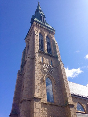
Guelph has had many prominent civic clocks, including the Bell Organ and Piano clock, the Scotiabank clock, the old Post Office clock, the City Hall clock, and the Floral clock. However, Guelph's longest-lasting civic clock is perhaps its most humble one: the clock of St. George's Anglican Church.

Since this clock has a subtle visual presence, it makes sense to start by pointing it out. Here it is in a Google Street View image:


The dial is visible just above the lancet window on the second storey of the tower. It may not be evident from this image, but the dial measures 6 feet or 1.82 m across. This view already suggests one reason why the clock does not pop out: It has a dial but no face. The gold arms and markings of the dial and hands also do not contrast sharply with the limestone wall of the Church. It seems that the clock was designed to blend in with the building rather than to stand out against it.

Postcard photographers certainly did not go out of their way to feature the clock. It is barely visible at a sharp angle in this postcard published by Progress Printing, Preston, Ontario around 1970:


(You can get a better view in pictures of the church from 1966 and from 1982.)

In spite of its subtlety, the church clock is the most time-honoured timepiece in Guelph. It was a gift to the church by the famous Arthur William Cutten. Cutten was the second of nine children born to Walter Cutten and Annie MacFadden (13 Apr 1870), a family of devout Anglicans. Arthur grew up in Guelph, attended church, and went to high school at Guelph Collegiate. However, rural Guelph could not satisfy this young man's ambition, so he lit out to Chicago in 1888, where he was employed as a bookkeeper. To make a long story short, Cutten used his modest income to speculate successfully on commodities and became a very wealthy man. However, in spite of his yen for the big city, he never forgot his little home town.

In the 1920s, Cutten lavished money on the old burg in general and St. George's Church in particular:

In Guelph he donated $20,000 to pay off the Guelph YMCA mortgage; he donated funds to St. George’s Church for stained glass windows, marble floors, a bell, an organ, and a carillon (the chimes alone were estimated to have cost over $25,000); to Woodlawn Memorial Park he donated funds for more land, iron fencing, entrance gates and other property improvements ($13,000) and was instrumental in creating the Cemetery Commission and establishing the Perpetual Care (Maintenance) Fund. As well, he provided financial support for all his siblings.
His best-known project was the Cutten Fields golf course, still a central feature of the Royal City.

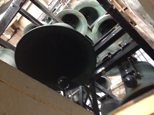
The clock was given to the Church in connection with the carillon, which included a set of 23 bells (now 36) mounted in the Church belfry and played from a touch-sensitive keyboard. St. George's carillon was only the fourth in Canada and was thus quite a bragging point for its parishioners. Both clock and carillon were made in Croydon, England by Gillett and Johnston (Mercury, 18 March 1926), makers of the carillon in the Peace Tower and a firm that continues in operation to the present day. The paper also remarks that the largest bell in the set weighed in at 1,745 lbs. (about 790 kg), so the device was clearly designed to produce a big sound.

The clock uses some of the bells of the carillon and rings every quarter hour from 7:15 am to 11:00 pm. In fact, the clock plays the "Westminster quarters", patiently described in the Mercury for the uninitiated:

At a quarter past the hour four notes will ring out; at the half hour, eight notes, the first four and four others to blend in pleasing melody; at the three-quarters, twelve notes; and at the hour sixteen, followed by the strokes, indicative of the hour.
In case that is not clear, here is a small clock sounding the Westminster quarters:


St. George's clock rings out the hours 24/7. It was initially powered by a system of weights that had to be raised up the tower twice a week by pulling on furnace chains—no small task! In the 1950s, this system was replaced with an electric one. Don Hamilton, the carillonneur of St. George's since 1987, notes that the original clock mechanism continues to serve well: It keeps time to within a few seconds a day and can be adjusted by changing a system of weights attached to its 4 1/2 foot pendulum.

I was fortunate enough to be given a tour of the clock and carillon by Mr. Hamilton. A steep and narrow stairway of 59 steps leads from the base of the tower up to the clock level. There, the clock sits mounted in front of the big lancet window facing onto the street. The clock can be seen striking the half hour in the video below:


Note the pendulum swinging in front of the window, the flywheel spinning in the background during the chimes, and mechanism on the right that pulls the chords connected to the bell clappers.

Up another narrow flight of stairs is the room with the carillon keyboard. This keyboard features a set of "batons", sticks that are arranged somewhat like piano keys and played by using fists to depress them. Acoustics can be controlled by varying the force used on the batons and by using a set of foot pedals beneath. The carillon of 36 bells at St. George's provides three octaves, enriched by the harmonies set up among the bells themselves.

Those bells can be glimpsed through a hatchway into the belfry on top of the keyboard room:


Note the clapper inside the bell on the lower left. Clappers inside the bells are attached to the carillon. Now, note the clapper on the outside of the bell on the lower right. Those bells with clappers mounted outside are also a part of the clock chiming mechanism.

The History of St. George's Church (Moore 1982, p. 77) notes that the carillon (and thus the clock) was ready for action on Saturday, 17 April 1926. The clock, carillon and organ were dedicated by Bishop Owen on 19 May (History of St. George's Parish 1832–1932, p. 81). The clock has kept time faithfully ever since.

One question remains: Why did Arthur Cutten donate the clock and carillon to St. George's Church? Mr. Hamilton notes that the church previously had a set of chimes in the belfry, which were not nearly as loud or sophisticated in comparison to a carillon. So, the clock and carillon would improve the church's acoustical profile and increase the pride of the parishioners in their edifice. In addition, not far away, the Catholic Church of Our Lady was having two magnificent towers added to its facade in 1926, considerably increasing its civic profile. St. George's Church was not in a position to compete architecturally but the clock and carillon may have provided a different way to keep up with the Joneses. Or, it may have been a coincidence.

Whatever the reason, the clock of St. George's Church remains the Royal City's most enduring civic timepiece.

Wednesday, 7 May 2014

The island in the Square

The City of Guelph is contemplating some further changes to its downtown spaces. One of the changes under consideration is the construction of a large roundabout in St. George's Square. The main aim of the proposal is to establish a convivial public plaza in the large space that the new design would create there. A mock-up of the new design appears in the draft Streetscape Manual produced recently by the city:


The report on downtown Guelph prepared by the Project for Public Spaces notes that:

Throughout history, St. George’s Square has always been a Central Square for the City of Guelph. During the past half century however, the Square’s more ceremonial and iconic elements gave way to more functional elements that were needed to support a growing city, namely transit service and a growing street network. Until very recently, St. George’s Square was the central bus transfer hub for downtown Guelph.
The proposed redesign would, among other things, return the Square to its earlier role.

Of course, the history of St. George's Square, and the space in its centre, is more complicated than that. It has been the site both of much traffic and of much controversy. A little of the story of St. George's Square appears in this earlier blog entry. However, since the Square has been of perennial interest to postcard makers, its history can be explored in this blog more thoroughly. For the present, I will outline this history and save more detailed accounts for later postings.

The Square began as a spot dedicated by John Galt to the Anglican Church. The first St. George's Church, a wood frame structure, was built in the middle of the space in 1833. Thus, it was the first island in the Square. Its location in the middle of Wyndham St. made it "one of the most conspicuous objects in the town..." in the opinion of a British visitor (Johnson 1977, p. 114). By 1851, the growth of the congregation required a larger church, and a stone building was constructed in the same location. As soon as 1859, however, prominent parishioners were seeking a new site for the church, one that was bigger still and removed from the commercial centre of the City (Johnson 1977, p. 223). By 1873, Dr. William Clarke had arranged for a new site (the current one) and the sale of the old site to the town. The second church was razed and the new one built at that time. After the rubble was removed, the Square stood empty for almost the first time.

The removal of the Church seems to imply that the townsfolk did not appreciate the detour that it necessitated. However, it did not take them long to seek out a new landmark to put down in the same place. In 1884, the citizens decided that the middle of the Square would be a good place for a fountain. The City Council collected donations, including a bronze statue of a blacksmith from local manufacturer J. B. Armstrong. The statue was placed atop a marble fountain and surrounded by a little garden, the whole becoming known as "The Blacksmith Fountain" (Couling 1996, p. 6).

The Blacksmith Fountain was octagonal in shape, framed by a small stretch of grass, and surrounded in turn by a short fence. It was joined by an arc-light on a pole for illumination. And thus, St. George's Square had its island back. A photo of the Square featuring the Blacksmith Fountain can been seen here.

The first major change to the island was the arrival of the Guelph Street Railway system in 1894. George Sleeman, the brewer, entered into what we would call a public-private partnership with the City to build a streetcar system (Johnson 1977, p. 285). As the tracks were laid up Wyndham St., they passed on either side of the Blacksmith Fountain. The Fountain then became an important stop along the streetcar's route. This confluence of uses proved fateful.

A good view of the Fountain as it then appeared can be seen on the postcard below. It was printed by Warwick Bros. & Rutter of Toronto.


The photo was taken in 1907. The presence of the clock face in the Post Office tower dates the photo to no earlier than 1907 and the Fountain was altered in 1908, as we shall see.

The photo provides an excellent view of the Fountain and its immediate surroundings. The plantings around it are rendered in green by the lithographer, and the streetcar tracks on either sign are quite visible. Also visible is the base of the arc-light pole on the Upper Wyndham side. Interestingly, serrations are also apparent on the top of the fence rails around the Fountain. It seems clear that the designers of the garden wanted to let no casual intruders near the structure. It was for viewing only!

In 1908, Guelph celebrated its first Old Home Week. Photos of St. George's Square during parades through the city (like this one) show that the island had been renovated. The Fountain appears unchanged but the garden around it has been enlarged and changed to an oval shape, with the long axis along Wyndham St. The oval neatly fills in the lines of the streetcar tracks around the Fountain. Also, the arc-light pole has been replaced by a flag pole.

Photos of Old Home Week that year tend to obscure the island (although this photo shows people sitting in it while enjoying a parade.) However, postcards from roughly the same time more clearly show the island after this renovation. The card below, for example, shows the island along with its new fence. Keep off the grass! Also, note that the arc light is now mounted on a wire strung across the Square.


This card was also printed by Warwick Bros. and Rutter of Toronto, although in halftone (now yellowed). In addition to the features already mentioned, you can see benches placed at the end of the island facing Upper Wyndham for people to sit on as they kill time or await the next streetcar.

One aspect of street life that stands out in those older pictures is that people, streetcars, and horse-drawn conveyances tend to mingle freely on the street. In those days, streets were regarded as public places. Thus, everybody had a right to be in them. Standing in the middle of the street talking or waiting for a streetcar, for example, were perfectly acceptable things to do. All that changed in the era of the automobile.

By the 1920s, people were committed to the automobile as their main means of personal transportation. As a result, other street users were pressured to change their ways. Streetcars struggled to compete for ridership, while people on foot were increasingly confined to the sidewalks. These trends are certainly evident in the changing fortunes of the island in the Square.

In 1921, the Guelph streetcar system was purchased by Ontario Hydro, which set about rationalizing its service. One of their first moves was to make changes in the layout of the island. The Blacksmith Fountain was removed and relocated to its new home in Priory Square, where it remains today. New streetcar tracks were run directly through the centre of the Square, while two half-oval gardens were planted on either side. In effect, the island was split in two. Its inside edges provided boarding platforms for the streetcars while benches were placed on its outside edges for people to sit in the street.

This configuration can be seen in the postcard below. It was printed by The Valentine & Sons United Publishing Co., Ltd., Toronto, from a photo taken ca. 1925. (It is postmarked on 1 April, 1931.)


The picture suggests how many cars were commonly on the street at that time. With increasing car traffic in the Square, the presence of a transit depot in its centre island seemed bound to create conflict. And it did! However, remarkably perhaps, the island in the Square persisted for quite a while yet. Among other factors, the Great Depression and the Second World War delayed any major changes in infrastructure.

One change that did occur in that time, however, was the replacement of the streetcars by busses. The streetcar system proved to be a money-loser for Ontario Hydro, which attempted to sell the system back to the City in 1926. No sale! Finally, the streetcars were replaced entirely by busses in 1937, which continued to use the island as a central depot.

The island of this era, now going by the name of "The Circle", can be viewed in this postcard from 1942 (Coulman, 1977, n. 211). It was published by the Photogelatine Engraving Co., Ltd., Toronto and was postmarked in 1953.


The Circle remains much as before, although it now plays host to buses, and there are no benches to allow people to sit in the street. Still, pedestrians are clearly expected to cross through traffic in order to get to the bus stop, a maneuver that grew increasingly dangerous as time went on.

After the Second World War, the economy picked up steam and car ownership resumed its climb. As such, the Circle had to go. In 1953, in the midst of much controversy, the City altered the island again. It increased the middle space from two lanes to four and placed concrete barriers along each side. The barriers discouraged pedestrians from walking through the middle of the Square to catch a bus.

This setup can be seen in the following postcard, taken on Dominion Day in 1954 (Coulman, 1977, n. 212). (Note the patriotic bunting hanging over the roadway.) It was published by the Photogelatine Engraving Co., Ltd., Toronto ca. 1955.


Not long after this photo was taken, the island was removed entirely. Bus stops were moved off to the sides of the Square. Now cars could pass along Wyndham Street straight through the middle of the Square without impediment.

The Street View scene roughly equivalent to the previous postcard would be the one below. No island there!


View Larger Map

The fate of the island illustrates the impact that automobile adoption had on many streets in older cities. Designed originally for foot and horse traffic, these streets were redesigned to more closely resemble highways, by widening and straightening. The island in the Square resisted this treatment for a long time, out of its centrality to public transit and perhaps the attachment of older citizens to the Royal City's established ways. These are themes that can be explored in further postings.

Setting aside any practical considerations, I find it intriguing to imagine being on foot on an island in the middle of the Square, having traffic pass around me like the spokes on a wheel turning about its hub. It is hard to imagine, though, since I am used either to fleeing across it on foot or to wheeling through it in my car. If the notion of putting an island back in St. George's Square is to succeed, it will have to capture the imaginations of Guelphites, who will now find it alien and unfamiliar.

Tuesday, 23 April 2013

The Speed River

This postcard provides a picturesque view of the Speed River, the main waterway of the city. This seems an appropriate subject for a posting of Guelph postcards on the anniversary of its founding, that is, St. George's Day (23 April).


The text printed at the top of the face says, "No. 461 View on River Speed, Guelph, Canada". As far as I can tell, the expression "River Speed" was never common but was used in writing to lend a poetic air to the name. On the back, the card identifies itself as "Published by Stedman Bros., Brantford, Canada. Made in Germany." The postmark is dated May 26, 1908. Stedman Brothers were a leading publisher of postcards in Canada, as you can see from this little video.

Views of the Speed were popular subjects for postcards of the city. Postcard publishers and buyers liked views of "beauty spots", of which tree-lined rivers were a prime example. Guelph, founded on the banks of the Speed near its confluence with the Eramosa, is well endowed with such places.

This picture reveals how cities were viewed as places where elements of nature could be combined with, and domesticated by, man-made structures. On the right edge of the photo is the spire of St. George's Church on Woolwich St., that towers above the river. In the center of the picture is the old Heffernan St. footbridge that spans it. Both represent people's ability to civilize the wilderness without banishing it, an ability that Edwardian postcard images of Guelph often celebrated.

The city's relationship to the Speed River was central to its founding. One of the reasons why John Galt selected the site for his city was the presence of the river. The native American name for it is not recorded (to my knowledge), but Galt named it, apparently, for the force with which it flowed. A fast river promised plenty of energy to power the gristmills and sawmills that would drive Guelph's growth. Also, being an author with a romantic disposition, Galt simply liked a good river.

To be useful, the river had not only to be tapped but also bridged. The immediacy of this challenge is made clear in the "Annals of the town of Guelph" (p. 29):

For the remainder of the summer [of 1827], he [Mr. Strickland] was employed in superintending the erection of several houses, and in building two bridges, one over the Speed, and the other over the Eramosa branch. That over the Speed, where Allan's bridge now is, appears in a painting executed in the fall of 1828, to have been a very substantial and not inelegant structure, built on piles, the superstructure being partly of squared timbers. This was of great convenience to the settlers, as a good number of farms had been cleared on the other side of the river, and the farmers had hitherto been compelled to cross on a rude ferry, consisting of a raft of logs lashed together; and as the stream, especially in the Spring, was very swift, this was frequently attended with considerable labor and frequently also with some danger.
Though rafts can make for great sport, a sturdy bridge does sound much more convenient, and civilized.

The use of boats to cross the river did not cease entirely, however. The Rev. Arthur Palmer, rector of St. George's, used to commute to work by boat, as Florence Partridge notes in "Slopes of the Speed" (1992, p. 18):

During the time that Palmer lived in the Arthur Street house, there was no footbridge, so he kept a rowboat which he used to cross the Speed River to his church in St. George's Square. The original footbridge was built in 1881 to provide pedestrian access across the Speed River between Arthur Street north and Woolwich.
Too bad for Rev. Palmer that he had moved away by the time the footbridge was built!

Here is a Street View image resembling that of the postcard, taken from yet another bridge over the Speed:


View Larger Map

This photo was taken from the Eramosa Bridge, just a little upstream from St. George's Church. It displays roughly the same scene the postcard photo, although it shows the new, and higher, footbridge built in 1918 and the blank side wall of the River Run Centre. It seems likely that the postcard photo was taken from this bridge (or, more accurately, an earlier version of it). It is remarkable how much remains the same between the two images.

The postcard is addressed to "Miss Ida Fissette, Simcoe, Ont." and conveys this very charming message:

Think I will make up for lost time now & write to you nearly every day. I am homesick today. Can you wonder at it? Are you tired? Clare
Poor Clare! She does not say what brought her to Guelph, but many young women from the region came to the city at that time to study Home Economics and Domestic Science at the MacDonald Institute (now part of the University of Guelph). Doubtless, many felt homesick during their studies. I wonder if Clare found any solace walking in the city taking in the many views of the Speed.

Happy St. George's Day!

Tuesday, 26 February 2013

St. George's Square

This panoramic postcard depicts the epicenter of downtown Guelph, namely St. George's Square, looking north.  The street to the left is Upper Wyndham St., whereas the street on the right is Douglas Street.


This postcard is an unusual one because it is, so far, the only double postcard in my collection.  That is, it is the width of two standard postcards.  If you look in the middle of the card, you can see a crease where it is designed to be folded in half, with the picture on the inside.  I suppose this arrangement makes sense since it leaves the destination address visible outside to the mail handlers.

The card was printed by the Warwick Bro's & Rutter of Toronto, which we have seen before.  The card was not sent or postmarked, so the date of production is unclear.  However, the scene itself can be dated by clues from the structures depicted in it.

For example, note the tower of the "Old Post Office" in the center of the picture.  In A Picture History of Guelph (p. 56), Robert Stewart notes that the clock was installed in the tower in 1906.  Since the tower is shown with its clock, it cannot be older that that.

Notice also that the streetcars in the picture are diverted around the fountain and plantings in the octagonal island in the middle of the Square.  (The fountain was known as "Blacksmith Fountain" and has since been moved to another location.)  A photo from the Guelph Public Library database, taken of the Guelph "Old Boys Reunion" in 1908, shows that the island had been replanted strictly with grass and restructured into an oval shape, with its long axis aligned with Wyndham St.  So, the postcard, with its octagonal island, cannot be newer than that.

Therefore, let's say that the photo in the postcard was taken ca. 1907.

One of the most basic questions about St. George's Square is, "How did it get that name?"  In the postcard, if you look down Douglas Street to the right of the Old Post Office, you can see the spire of St. George's Anglican Church reaching upwards at the end of the block.  In fact, St. George's Church was originally located in the middle of the Square, right about where the Fountain later stood.  As noted in the History of St. George's Parish (p. 3), John Galt, the founder of Guelph, had "set aside for the Anglicans a plot of rising ground where they might build their church."  The first St. George's was a frame building, followed by a stone structure on the same site.  However, a third and perhaps more convenient St. George's Church was built from 1870 on Woolwich St., at the end of Douglas.  This move allowed the creation of St. George's Square, a generous public space in the middle of the city, named in honour of the structure that made way for it.

St. George's Square remains the middle of downtown Guelph, although its configuration and environment have been profoundly altered, as the current Google Streetview image shows:


View Larger Map

There are plenty more views of St. George's Square, so we shall return!