Postcards of Guelph, Ontario, Canada, from my collection, spanning the early 20th century to the present. Click on postcard images to see them enlarged, and on Street View images (where given; copyright to Google) to compare with the present-day city. Also, check out my Flash from the Past columns with the Waterloo Record.
Because they were souvenirs, old postcards of Guelph (like many other towns) put churches, train stations, public buildings, and beauty spots at the centre of attention. However, it is sometimes interesting to peruse the periphery of these images. There may lie items that were not deemed of interest to casual shoppers but are of interest in the city's history.
Consider the image below, from a postcard printed for Charles Nelles around 1910.
This picture was taken from the Central School and looks towards St. George's Square. A number of buildings still present today are visible in it, such as Knox Church, Chalmers Church (now Royal City Church), St. George's Church, and the Wellington Hotel.
Scan the horizon on the right and an unfamiliar cylinder appears on the brow of what was then called Horsman's Hill in the St. George's Park neighborhood. This was the Royal City's first standpipe, then the tallest item in town. At the time when the photograph was taken, the standpipe was very new, a highly visible symbol of the city's progress and, according to its admirers, the pride of Mountain Town.
In this case, a standpipe is a cylindrical tower used as a water reservoir. Guelph acquired one because it was experiencing trouble delivering water to its residents, businesses, and fire fighters—a perennial problem for modern cities.
From its early days, Guelph's central water supply system consisted of an iron hand pump. This "town pump" was located at the corner of Wilson and Carden streets, and had four sweeping handles that could be cranked manually to produce water from a well. To fight fires, water was pumped from such fixtures into a tank incorporated into a horse-drawn fire truck.
As the town grew and fire posed a greater threat to life and property, such a system was found inadequate. Schemes to provide centralized water distribution through pipes were proposed as early as Confederation but design and construction of a waterworks began in 1879, the year Guelph became Ontario's ninth city and acquired the moniker "The Royal City." A pumping station was erected along the Eramosa River and ten miles of pipe had been laid by the end of 1880.
As time went on, shortcomings of the system became more acute. Water drawn from the Eramosa river could be discoloured at times. Tests revealed "colon bacilli" in the water. As more residents, businesses, and services joined the system, its capacity became inadequate. Also, changes in pressure from the pumps damaged the pipes, resulting in leaks and breakages.
A standpipe helps to deal with problems of variations of pressure. Instead of feeding water to the system directly from a pump, which causes a surge whenever the pump is turned on and then a subsidence when it is turned off, a standpipe provides constant pressure as water can flow steadily downhill through the system from its fixed, elevated reservoir.
In 1907, the City set up a Water Commission to recommend changes to the system. The Commission advocated the idea of bringing clean water to town from springs at Arkell in Puslinch. The City adopted this plan, bought about 70 acres (about 28 hectares) in Arkell and had a pipeline laid to bring spring water to Guelph.
The standpipe was built to deliver the water in abundance and at an even pressure. Naturally, the structure had to occupy a high point in town and near the waterworks, so Horsman's Hill was an obvious choice. A special section of the Evening Mercury (13 March 1909) provided a gushing account of the new system, including the Royal City's outstanding new cylinder.
("The Stand Pipe", Evening Mercury, 13 March 1905.)
The enormity of this towering achievement is described in every way possible. It is said to be the largest standpipe in Canada at the time, of prodigious proportions:
The standpipe is thirty feet in diameter and 100 feet from base to top. An iron ladder runs perpendicularly up its south side to an iron platform and railing which encircles it near the top. The capacity is 500,000 gallons.
...
The base is of concrete. The first two rings are of 13/16 inch steel plates and these gradually decrease in the ascent to 3/8 inch. The structure itself with base, with water, when full, weighs 3,200 tons.
...
The work on the foundation for the standpipe was started on June 1st, and was satisfactorily completed within eleven days. A staff of fifteen men were employed on this contract. The foundation is 32 feet square and is 7 feet thick, and its immense strength can be judged by the tremendous weight that it must uphold. The excavation amounted to 428 cubic yards.
The amount and uniformity of the water pressure delivered are also spelled out in detail:
When it is full it gives 43 pounds pressure at the base. At the post office it gives 75 lbs. pressure when full. There is 50 lbs. pressure on the ground floor of the General Hospital. Pumping direct it is possible to give as high as 140 lbs. pressure at the Hospital. At other points in the city, of course, there are different degrees of pressure, according to the elevation. The load is always the same. The latter does not vary more than two pounds in the 24 hours. With the old pumps, the pressure varied from 45 to 110 pounds. So long as the standpipe is full there will be exactly the same pressure at a given point, whether one or ten streams are being drawn from it.
The system was also admirably suited to the demands of fire fighting in 1909:
The fire underwriters standard stream requires that a 1 ½ inch nozzle at the end of a single line of hose 250 feet long, will discharge 500,000 imperial gallons in 24 hours, with 80 lbs. pressure at the nozzle. That equals 200 gallons per minute. The fire underwriters call for ten standard streams the same as this for a town the size of Guelph. Such, then, is the capacity of the pump that the department can run 50 per cent, overload, or 4 ½ million gallons per 24 hours, in addition to having ½ million gals. in standpipe.
Residents of the Royal City could be forgiven for beaming with joy when they saw this new monument to progress overlooking their fair city, on the brow of "Mountain Town," opposite the Central School and the Church of Our Lady.
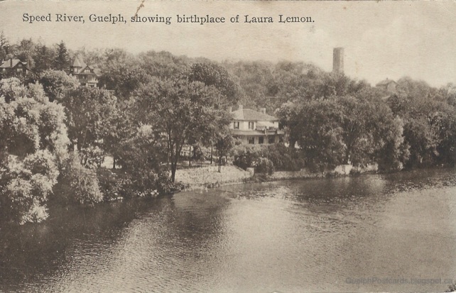
The standpipe appears in other postcards as well, though always in the background. Perhaps the best image is in the real-photo postcard below, with the standpipe looming behind a house on the Speed River, ca. 1910.
The message on the back of the card adds:
Xmas Greetings
Minnie & girls on River Bank on our lawn 34 Queen Street Guelph
That address is now 34 Arthur street N. Built in 1866 for Robert Melvin, who was Mayor of Guelph 1875–1876, the house was originally called Calderwood (Partridge 1992, p. 16). The name "River Bank" is very suitable, as it sits on the bank of the Speed directly opposite the onetime location of the Priory.
One hopes that the residents of River Bank appreciated the chance to live in the impressive shadow of the giant new standpipe.
The standpipe appears in the background of another postcard, printed by the F.H. Leslie Co. of Niagara Falls around 1935.
In the foreground is the house where Guelph's early musical celebrity Laura Lemon was born. In the background is the great standpipe.
The standpipe was located in the space between Grove street and Prospect avenue, in behind the current location of Hillcrest Park. In the map below, its approximate location and footprint is represented by the big black circle.
In 1968, the city waterworks were updated and the mighty standpipe removed. Yet, its sizable silhouette still lurks in old photos and postcards of the Royal City, where it stood ready to deliver fresh water for nearly 60 years.
Good sources of the early history of Guelph's Waterworks can be found in these issues of the Guelph Mercury:
13 March 1909, "Water works section," pp. 11–16.
20 July 1927, "Town pump yields place to modern electric equipment," p. 6.32.
On the name "Mountain Town" for the St. George's Park area, Ross Irwin (2008, p. 2) explains:
In 1829, John McDonald, PLS, the Canada Company surveyor of part of the township, acquired 186 acres east of the River Speed bounded by Metcalfe Street, Eramosa Road, Grange Street, and Budd Street. It was named "Mountain town".
Though the height of the drumlin on which the St. George's Park area sits is considerable, the term "mountain" does seem like an overstatement, of the sort usual with real estate developers. The name was very rarely applied, that I am aware of, though it is interesting that it persisted long enough to appear in the Mercury in 1909.
The Speed and Eramosa rivers have always been central to life in Guelph. John Galt chose a site by the Speed so that the swift current of the river could provide water power for mills that would process grain and lumber harvested from the surrounding region. As a result, mills shaped the early geography of the Speed, as occurred at Goldie's Mill.
Unlike the Speed, the Eramosa river keeps a languid pace, making it less attractive for milling. In the town's early days, the Eramosa (often known as the Eramosa branch of the Speed) was remembered for its use by an immense flock of passenger pigeons for a rookery in 1835. Of course, it was also used as a source of water for people and animals.
As far as the citizens of Guelph were concerned, the Eramosa came into its own later in the 19th century as a place for recreational boating. Increasing incomes allowed for some leisure time and extra cash to spend on boating gear. The usually docile current also rewarded the rowers' or paddlers' efforts more easily than did the Speed.
(Stereograph of rowers at Victoria Park on the Eramosa River. Note the Victoria Road bridge in the background. Courtesy of Guelph Civic Museums 2014.84.73.)
At the same time, around Confederation, rowing began to gain nationwide attention as a sport. In 1867, Robert Fulton, George Price, Elijah Ross, and Samuel Hilton, of St. John, New Brunswick, crossed the Pond to compete in regattas against top European Crews. The arrival of these "colonists" was greeted with some derision but the sneers vanished as the team left their competitors in their wake. They won the Paris Exposition regatta, becoming famous thereafter as the "Paris Crew." In England, they beat the cream of the Oxford University, London, and Leanders clubs—all this in an old-fashioned boat 100 pounds heavier than their rivals'. They returned to Canada to a tumultuous welcome.
The success of the Paris Crew was followed by that of Edward "Ned" Hanlan of Toronto Island. Ned Hanlan developed a local reputation competing in single sculls events in the early 1870s. He won the national championship in 1877 over a five-mile course in Toronto Bay.
From 1878 until 1884, Ned Hanlan covered himself in glory. He won the American championship in Pittsburgh in 1878, the English championship in 1879 on the Tyne, and the world championship in 1880 on the Thames in London before a crowd of 100,000 spectators. This victory made Hanlan Canada's first world champion in an individual event and an instant hero throughout English Canada.
Hanlan's popularity, celebrity even, resulted as much from his showmanship as from his rowing. He often toyed with opponents, slowing down, taunting them, blowing kisses at spectators, faking collapse or rowing in zigzags. (The English press lectured him sternly for his flamboyance.) He was easily Canada's "first national sporting hero," at least in English Canada. After his first English triumph he was met back home by a flotilla 5 kilometres long. In New South Wales a town was renamed Toronto in his honour. He endeared himself to Torontonians by stressing his Canadian identity. He actively took part, like any celebrity today, in numerous promotions, particularly in whistle-stop autograph tours on the eve of races. He organized his own touring shows, raced local heroes, and indulged in showboating, performing tricks such as rowing in a straight line with only one oar.
Rowing fever quickly spread to Guelph. In April 1870, the first Guelph Boating Club was organized, accounting for about 35 members (Hacking 1873). The focus of the club was on boating for pleasure and they took some trouble to clear the river of obstructions so that it could be more easily navigated.
Indeed, it seems likely that boaters set out the local geography of the Eramosa River that remained so familiar to Guelphites for about the next fifty years. Hacking's city directory (1873, pp. 18–19) makes mention of several locales along the river connected with boating:
The Eramosa branch is specially admired by pleasure-seekers. Some distance up is an island known as “Rice Island,” and, higher yet, a spot that from its beauty has been christened “Paradise.” The approach to this spot is very fine, especially within half-a-mile of Victoria Bridge, where the long straight watery avenue, thickly clad with shrubs, and the bridge seen in the distance has a really artistic effect. Another place of resort is “The Rocks,” where good duck-shooting is to be had. Here commence a series of shallows, beyond which boating is impracticable.
Several now unfamiliar names occur here. At the time, there was only one island in Eramosa River near Guelph, a small island near the foot of Bell Avenue. Presumably, this place is Rice Island. There is no explanation given for the name but it may be that wild rice was observed to grow there. On Google Maps, the island has been dubbed "Goose island," presumably for the favor it has found with some Canada Geese. (See map below.)
Paradise refers to the area where the Eramosa bends southward about a half-mile east of the Victoria Road bridge. Today, this area is occupied by the Royal City Jaycees Park and the neighboring land subsequently turned into lakes by prisoners of the Reformatory in the 1920s–30s. Paradise was known as a beauty spot and a picnic ground. For example, the Daily Mercury (23 June 1879) relates that:
Chalmers’ Church Bible class boated to Paradise on Friday last and pic-nicked in the beautiful shade to be found there. It was a pleasant party.
Apparently, amenities such as swings and seats were provided. In 1880, the locale is described as "Bradley & Craig’s pleasure grounds," Bradley and Craig being the proprietors of the brand new boat house erected near the Dundas Bridge (and the site of today's Boat House and Tea Room). This note implies that Bradley and Craig had built up an integrated business: renting out boats in the town and arranging a pleasant destination in the township for customers to make for.
(Bend of the Eramosa River at Paradise, 2017. Author's photo.)
In addition to such feminine pursuits as swinging and picnicking, Paradise offered more manly forms of amusement (Daily Mercury, 9 June 1880):
Take care.—Pleasure parties going up the river to Bradley & Craig’s pleasure grounds at “Paradise” yesterday, report random shooting at the range while boats were passing up and down, and no red flag shown. The whistling of a bullet and report as it strikes the target may suit the ears of men and growing boys, but when ladies and children are on pleasure, it will be well for the marker and marksmen to have a care. It will be well, too, for passing navigators to stop and give some kind of alarm when in sight of the target, and then pull by as quickly as possible when the red flag is hoisted.
Today, Guelph rowers must find other incentives for pulling hard on their oars than dodging bullets.
The directory also mentions "The Rocks." The location of this feature is cleared up in the reminiscences of David Allan (1939, p. 98) where he recalls that The Rocks had later become a quarry used by the Reformatory. This locates The Rocks on the north bank of the Eramosa close to Stone Road.
(The Rocks, after quarrying by prisoners of the Ontario Reformatory, 2017. Author's photo.)
The Rocks are part of a series of rocky prominences along the Eramosa River, which were given the name the Eramosa formation in its honour. Geologically, these "Guelph dolomites" take the form of compressed layers of bituminous shales and may be as old as 425 million years.
Speaking of The Rocks in particular, Williams (1915, p. 2) notes that:
South of the prison farm near the Eramosa river, a coral reef rises through Eramosa beds which have been eroded from its top but still flank its sides. The reef is 35 yards wide by 85 yards long and rises about 20 feet at the centre.
It is interesting to think that the banks of the Eramosa River were once the site of a coral reef.
Besides their interesting geology, The Rocks were known as a good place to find wild food. Ducks for shooting have already been mentioned. In the summer, wild berries could also be found there (Mercury, 25 July 1904):
A party of berrypickers, on the dairy farm at the Rocks, of which there are quite a number, had a fright on Friday. One of the ladies nearly tramped on a snake about three feet long. They thought that it was a rattle snake by the sound that it made in its flight. It was a question of whether the ladies or the snake were more scared. Apparently the snake went for its cover, but it is certain that the ladies left the berry patch for home.
As Guelph grew, the geography of the Eramosa sustained more alterations. On 25 June 1886, another private park took shape on the south bank of the Eramosa just west of Victoria Road. The Park was named Victoria Park, after both the nearby road and, of course, the British Queen. The Boating Club made arrangements to rent the land from its owner, Mrs. Evan MacDonald, cleared it up, added tables, chairs, and other amenities suitable for picnics and camping. A sturdy dock was installed on the riverbank, along with stairs carved into the Eramosa rock for the convenience of those arriving by boat or from the nearby road.
A lovely description of Victoria Park is provided in a letter sent as an advertisement to the Acton Free Press to entice customers from further afield to enjoy the Park's offerings (22 July 1886):
... the banks are replete with natural beauty; green hedges dotted with flowers, and interspersed with vines that mount in tangled profusion to the tops of the trees in some places, and fringed at the water’s edge are ferns reflected in the clear mirror of the river, and you row along in a fairy land of nature’s own. You land at a broad wharf when you reach Victoria Park, and a sidewalk of strong planks winds away inland through ferns and tangled brushwood, and mounts on a strong stairway, with romantic seats here and there, the face of the precipice. Or, if you wish a glimpse of moss-grown boulders and lovely lovers’ walks, leave the plank walk and follow the path round the foot of the rocks which tower high over your heads, where you will find much to interest you, especially if you have with you the one person of all the world to you, to help you enjoy it.
If you mount the steep stairway you will find a high dry open space, with grand trees here and there, seats are placed round some, swings are hanging from others, and there is plenty of scope for the largest party to have the best of all good times.
The dock, seats, and swings are now gone, but the place where Victoria Park used to stand can still be accessed from the Guelph Radial Line trail or the easternmost hole of the Cutten Fields golf course.
(Victoria Park Landing, Guelph, ca. 1910, published by W.G. Macfarlane, Toronto. Author's collection.)
Later reminiscences cast a rosy glow over the pleasures of Victoria Park. During the warmer weather, people would often paddle out every Friday to camp there for the weekend. The most determined clients would camp there all summer, paddling downriver for work each morning and returning each evening.
Boating together was considered a highly romantic activity and it was said that, "Many a prominent business man in Guelph today can look back and thank the old canoe excursions for the helpmate who has been his life partner since those days of carefree companionship" (Mercury, 20 July 1927).
During its heyday in 1895–1900, boating to Victoria Park was a focus of leisure activity for many Guelphites. Campers would enjoy musical entertainments including the singing of a young Eddie Johnson (later a world-famous tenor) and the piccolo playing of Arthur Wheatley. At midnight, boaters would return to town en masse, still singing:
All the way, the river valley would echo and re-echo to the noisy choruses which were shouted lustily all the way down. Hands and arms would be made into grappling irons and the great armada of frail craft would be welded together on the return trip. Only those in the rear would paddle, and that just enough energy would be expended to keep the fleet in motion.
Another landmark arrived on the Eramosa River in 1888 in the form of a bridge to service the new Guelph Junction Railway, which initially ran from the Priory to the Canadian Pacific Railway (CPR) line at Campbellville. As the railway is operated by the CPR, the bridge is often referred to simply as the CPR bridge.
(The River Speed—Guelph, Ontario. Publisher unknown. Note the CPR bridge in the background. Author's collection.)
Although viewed with great fondness, the Eramosa River, like the Caney Fork River, is a taker and a giver. A number of boaters drowned in its waters and accounts of these events relate more of its geography to us.
The most noted drowning in the Eramosa in that era was of Hector Cooper and Eugene Gagnon on 24 May 1905. Cooper was then finishing his third year at the Ontario Agricultural College (OAC) while Gagnon, of Quebec, was taking commercial and English training at the Central School in preparation for studies at the OAC (Evening Mercury, 25 May 1904). The boys had become good friends and had decided to go for a paddle up the Eramosa at 4 o'clock that afternoon. They rented a canoe at the Boat House and set out.
A half-hour later, their canoe and a coat were found floating on Hood's bay by other boaters. Upon being informed, Mr. Johnson, owner of the Boat House, suspected that the boys had tipped over and set out for home to dry out, leaving the canoe for him to bring in. This sort of occurrence was not an uncommon one. Nevertheless, finding some of Cooper's letters in the coat pocket, Johnson sent word to the OAC to locate the boys. When Cooper was not to be found, a search party set out along the river. Cooper's body was found a few yards west from the corner turning into Macdonald’s spring. Gagnon's body was found a few hours later about fifty yards further downstream.
Both boys were fit and Hooper was said to be an excellent swimmer, so the cause of their drownings remained a mystery.
The term "Hood's bay" likely refers to George Hood, a butcher who had lived on a property on the York Road at the intersection with the eponymous Hood Street, still bearing that name today. His property backed onto the Eramosa river near where it changes from a westerly to a northerly heading. At a guess, then, Hood's bay may refer to a stretch of the river that widens out northwest of this bend, behind the location of St. Mary's Ukrainian Church today.
(Hood's bay, 2018. Photo by author.)
The feature referred to as Macdonald's spring must then be what local cartographer Jeremey Shute calls Whiteley's Creek, which rises on the University of Guelph campus and flows down through the Cutten Fields, emptying into the Eramosa River just east of Hood's bay. The Macdonalds owned the property on the south bank of the Eramosa in town and their home and other buildings lay near this stream.
Last, but not least, among the familiar places in the landscape of Eramosa boating was the Waterworks. The city Waterworks were built at the foot of Ontario street on the banks of the Eramosa in 1879. Since the waterworks were public property, the location was treated as a public park and boaters with their own craft would use it as a launching point.
Unfortunately, the accessibility of the waterworks also made it a hangout for idle young men. Sometimes, these "loafers" amused themselves at the expense of boaters (Mercury, 14 June 1887):
Bad boys—there is a fine opportunity for the police to nab the number of bad boys who congregate lightly on the Rivers edge in the bushes behind the water works. They sit there, and as every boat goes past, most vulgar and unbecoming remarks are made about the occupants, which are most revolting to the ears of the lady occupants as well as the gentleman. The employees of the water works, although having nothing to do in the matter, for the sake of decency chase them away whenever they can, but the young scamps are so wide-awake that whenever they see them approach they scamper off among the bushes and hide, only to return again when all danger is passed. A policeman in plain clothes would have no difficulty in nabbing the whole gang.
Whether or not these miscreants were ever caught I do not know.
As postcards of the Edwardian era attest, boating on the Eramosa remained a popular pastime. However, the Guelph Boating Club of 1895 came to grief in 1900. An attempt to form a new club was made in 1927 but did not succeed. With the adoption of automobiles, people took drives out in the country to have their picnics. There was talk of paving parkways along the Speed so that it could be enjoyed by car (Mercury, 28 September 1918), though the money to do so was lacking.
(Scene on the river Speed, Guelph, Canada. Published by the International Stationary Company, Picton, Ontario, ca. 1910. Author's collection.)
In addition, the geography of the Eramosa was the subject of more changes, for example, with the arrival of the Ontario Reformatory. However, that is a matter for another time.
As noted in an earlier post, St. George's Square is the centre of some controversy. The Square is due for some infrastructure upgrades and, it is proposed, some reconfiguration. More specifically, one proposal calls for the establishment of a large island in its middle. The island would be the site of various attractions and events, as yet not specified.
In that earlier post, I summarized the history of the previous island in the square. That history began with the construction of the Blacksmith Fountain and its surrounding garden in 1885. Of course, that history leaves open an important question: How did the Blacksmith Fountain get there? That takes some explaining.
Here is another postcard in which the Fountain has center stage.
If you look closely at the edge of the grass right under the Fountain, you can see an old reel lawn mower. There also appears to be a young man relaxing behind a post at the left edge of the grass. Perhaps he is supposed to be pushing the mower.
How do you like these stone buildings? The P. O. [Post Office] is in the foreground. Am here at the Winter Fair. Your letter came safely and will answer soon. P. F. C.
In fact, the Fountain is in the foreground. The P.O. is in the background. Nevermind.
As with the current situation, the story of the Blacksmith Fountain begins with some infrastructure upgrades. In 1878, the Royal City began planning a water works, that is, a system of town-wide water distribution through pipes from a central reservoir, located upstream of the town on the Eramosa ("Guelph water supply", Gilbank 1969). By the end of 1880, some ten miles of pipe had been laid.
The aim of the effort was focussed on the provision of hydrants for fire control. Some 94 were positioned by the end of 1880. However, the townsfolk had further ambitions for the system. As Alderman Read put it in 1883, after the citizens had sunk thousands of dollars into the construction of the water works, they still could not get a drink (Guelph Mercury, 21 Aug. 1883). Already in 1880, people were thinking in terms of a fountain for St. George's Square (5 May 1880):
The suggestion had been made that a cheap drinking fountain for horses should be placed in the centre of St. George's Square. The city may contemplate placing a large fountain there at some future day...
No cheap fountain was put in place, that I am aware of. However, the idea for a grand installation seems to have stuck in people's minds.
So, the infrastructure was underground and the idea was in the air. However, the cash was lacking. That problem was addressed by the generosity of the city's leading men of industry. In the summer of 1883, the town council received a "liberal offer" from Mr. David McCrae (see photo here). McCrae, father of the famous John McCrae, was a farm owner and animal breeder, co-owner of the profitable Armstrong, McCrae & Co., a woolen clothing factory, and also captain of the Ontario Battery of the 1st Provisional Brigade of Field Artillery, formed in 1880 (Johnson 1977, p. 211). Mr. McCrae offered to pay the town one or even two years of his taxation exemption (think "tax refund") as a contribution towards some civic improvement (21 Aug. 1883). The council leaped at the chance and talk turned immediately to fountains. Alderman Read suggested four or five "not expensive" fountains might be placed around the town. Alderman Stevenson, however, was keen on something more dramatic:
Ald. Stevenson was in favor of having something grand–say an imposing fountain on St. George's Square, and the work to be commenced at once.
Alderman Laing suggested a park. However, Ald. Stevenson's idea carried the day and the council struck a Special Committee to pursue the matter.
By October, it became clear that the council did not have money enough for the imposing fountain it desired. It is not clear why. Either McCrae's donation was not sufficient, or perhaps they split it up amongst several projects. In any event, they began to look for additional sources of funding (2 Oct. 1883).
The Committee collected money by subscriptions throughout the fall and winter. In this way, they collected the substantial sum of $500 (8 Apr. 1884). However, the breakthrough came in May with the arrival of another generous donation from a well-to-do business man, Mr. J. B. Armstrong. Mr. Armstrong sent the following open letter to Mayor Caleb Chase, reprinted in the Mercury (6 May 1884):
To His Worship the Mayor and Corporation of the City of Guelph:
In reply to a wish by the Council toward erecting and fitting up a fountain on St. George's Square, I beg to say I should be pleased to present the city with a fountain according to the accompanying design, the other subscribers to furnish the base surrounding and fit it up. It will be about 12 or 14 feet high, the central figure representing Industry.
Mr. Hall has kindly furnished the accompanying sketch, and will furnish you any particulars you want.
Yours very truly,
J. B. Armstrong.
Too bad that the paper did not publish the sketch!
J. B. Armstrong (who seems always to be referred to as "J. B." instead of "John" or "James") is listed as a 33-year-old carriage maker in the 1871 census. The Industrial Number of the Mercury in 1908 states that the business was founded in 1834 and incorporated under the name J. B. Armstrong in 1876. Its addresses were 41, 43 & 45 Macdonnell St. Clearly, Mr. Armstrong was doing well.
Why he decided to contribute to the fountain in St. George's Square is not clear. Perhaps he was related to the Armstrong who was David McCrae's business partner and was persuaded to climb aboard the project. Perhaps, like Mr. McCrae, he was a civic booster with a desire to improve the city and make a splash. Perhaps he thought that a monument to industry was overdue. None of the material I have found makes the matter any clearer.
The City gratefully accepted the offer. The form and location of the fountain were now set. However, even with this generous donation, funds were a little short (20 May 1884). That is when the Guelph Amateur Dramatic Club entered the stage.
The Amateur Dramatic Club (ADC) was a group of drama enthusiasts who put on occasional performances in the city. Sometimes, they would donate their box office proceeds to worthy causes. The ADC had just put on a performance of a drama called "Meg's Diversion" and the farce "Done on both sides." The show was a sell-out and the ADC had decided to put on another performance with the proceeds going to the Fountain fund. The proposal, made in a letter to council by ADC President, Mr. E. F. B. Johnston, was immediately accepted (2 Jun. 1884). And so, Guelphites were treated to a repeat performance.
The plot of Meg's diversion is complex (30 May 1884). Meg is persuaded by her father Jeremy Crow to affect feelings for Jasper Pidgeon so that Jeremy can borrow money from Jasper to pay off his looming debts. The ruse works but is then exposed by Japser's older brother Roland. Roland then pursues Meg and wins her affections. However, Meg then discovers that Roland really loves her sister Cornelia and was merely toying with her for revenge. Cornelia, though, is promised to Ashley Merton, Esq. However, Ashley actually prefers Mrs. Netwell (who, I assume, is a widow) and so is relieved to give up his engagement to Cornelia who, then, is free to marry Roland. Jasper, meanwhile, renews his attentions to Meg, who finds that she loves him after all. Finally, Jasper discovers that he has made a fortune (it is not clear how), meaning that he and Meg can live happily ever after in spite of their devious relatives.
The performance was praised in the Mercury:
Miss [Lizzie] Mercer ["Meg"], always a favorite on such occasions, excelled herself... She was accurate throughout, and succeeded in bringing out the double character of a flirt and sincere lover very successfully. ... Mr. [E. F. B.] Johnston ["Jasper"] brought out effectually the value of the true heart and honest, manly character and bearing which belonged to the rough exterior of the carpenter.
The farce Done on both sides is less complex. Mr. Brownjohn visits the Whiffle family to woo Lydia Whiffle and invites himself to dinner. The Whiffles are perplexed because they are hard up and have nothing to eat. The situation is saved by the timely arrival of Mr. Pygmalion Phibbs who is a veterinary surgeon carrying a haunch of venison as a gift for the President of the Veterinary College. The Whiffles tell Phibbs that Brownjohn is the President, whereupon Brownjohn orders Phibbs to prepare the venison for the family dinner, much to Phibbs' dismay. Finally, the truth is revealed and everyone, ludicrously, is reconciled.
The audience seems to have enjoyed it. Perhaps the characters were parodies of local bigwigs.
The event raised around $40 or $50 towards the fountain, which was considered an appreciable sum (6 Jun. 1884). Perhaps it put the project over the top. Mr. J. B. Armstrong soon gave the contract for construction of the granite foundation to Mr. J. H. Hamilton (14 Jun. 1884), owner of a "Monumental Works" on Woolwich St. founded in 1871. The measurements for the statue's base were four feet square by eighteen inches high.
The statue of a blacksmith is cast in a metal alloy. Supporting the statue is an octagonal basin, held by a Rococo-style cast iron pedestal. The water spouts from the mouths of eight rams heads that decorate the basin's rim. The base is constructed of red-granite and bears the historic inscription, “Presented by J.B. Armstrong 1884”.
But the tale of the origin of the Blacksmith Fountain is not a tale of iron and granite. It is a tale of plumbing, industry, and amateur dramatics.
PS. The Blacksmith Fountain was removed from St. George's Square in 1922 so that the roadway could run through the middle of the Square. If the middle becomes an island again, should the old gentleman return as well? What would the Fountain Family say?