Showing posts with label Grand Trunk Railway. Show all posts

Saturday, 9 December 2023

An International Stationery Co. tour of Guelph

Yours truly recently gave a talk at a meeting of the Kitchener-Waterloo-Cambridge-Regional-Post-Card Club (KWCRPCC). This was the Club's first meeting since the arrival of the COVID pandemic, so it was an honour to help the group resume operations after a long hiatus.

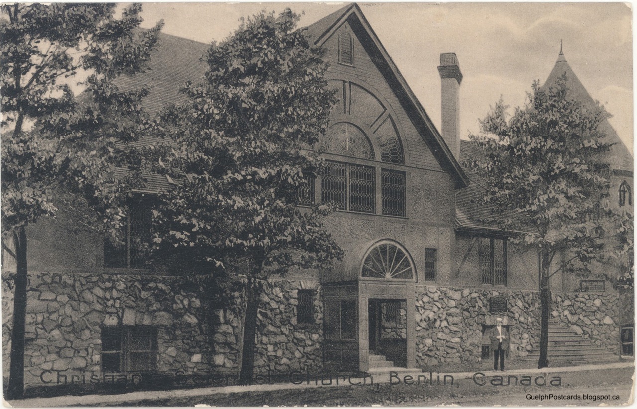
The venue was the historic First Church of Christ, Scientist in Kitchener. As it happens, the church itself features in some old postcards, such as the following:

("Christian Scientist Church, Berlin, Canada," ca. 1909. Courtesy of Leigh Hogg.)

(First Church Christ, Scientist; courtesy of Google Maps.)

The subject of the talk was the postcard views of Guelph as provided by the International Stationery Co. (ISC) of Picton, Ontario. In this post, I will give a precis of the talk and show some of the images. The point of the presentation is not to give a history of places shown but to give an impression of the aesthetic quality of the individual postcards as pictures and of the whole set as a curated show of the Royal City as it then existed.

Among Canadian deltiologists, that is, postcard collectors, the ISC is known for its set of fine sepia-toned collotype postcards from the early 20th century. Consider the example below.

("Collegiate," #130.)

This is the predecessor of the current Guelph Collegiate and Vocational Institute, shown from near the corner of Paisley and Arnold streets. For inventory purposes, ISC numbered their cards; this card is number 130. The photo is nicely layered, with paths leading from the foreground into the image, where people can be seen walking under the trees and in front of the pointy buildings. Clouds billow upwards in the sky, drawn there by arists in Germany, where the cards were printed. As will become evident, this composition is typical for cards of Guelph from this set.

The history of the ISC goes back to "The Fair", a kitchen supply and grocery store located in Picton and founded by local boy James Livingstone (1868–1949) in 1895. The Fair was successful and expanded into new locations and goods. As the postcard craze took hold in the Edwardian era, Livingstone got into the act. Postcards turned into a big business for the ISC, which specialized in views from southern Ontario and the Montreal area. It carried on for some decades and left an interesting legacy of topical views.

To judge from postmarks, postcards of Guelph began circulation in 1913 and persisted into the early 1920s. Serial numbers range from 100 to 199, suggesting that there are about 100 views of Guelph in the set—quite a few! ISC expert Ian Robertson reports about 900 cards total in his collection, so the Royal City seems to have enjoyed attention disporportionate to its modest size. What was the charm?

The ISC set includes views of the usual suspects, such as the card below of the Carnegie Public Library. Designed by local boy William Frye-Colwill and erected in 1905, the building was a regular part of postcard sets of Guelph. Images were almost always taken from diagnoally across Norfolk street, which produces this dramatic angle. Even so, the photo appears to have been taken especially for the ISC.

("Carnegie Public Library," no number.)

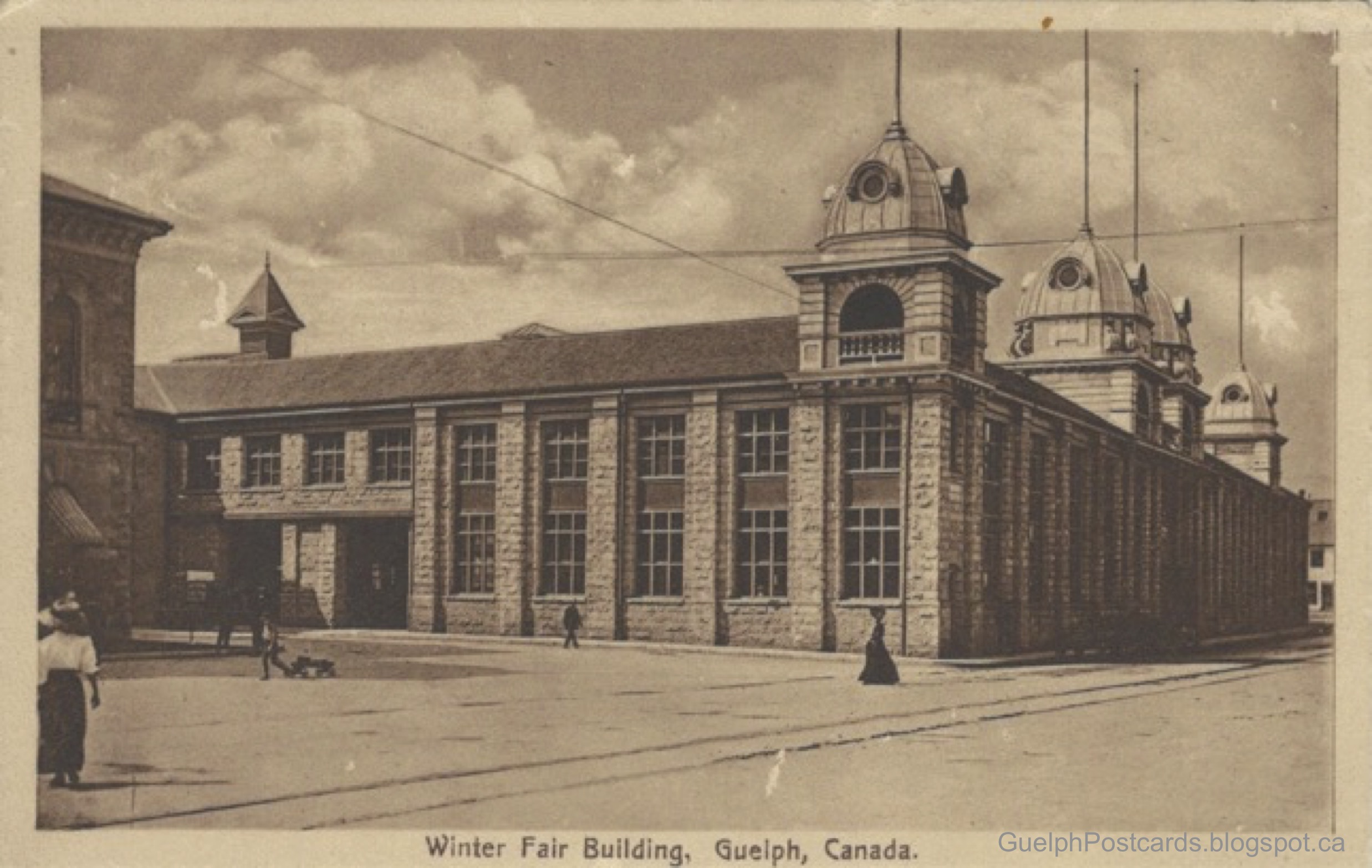
The Winter Fair Building is another fine card. The building was located on Carden street, in front of the new City Hall, where the splash pad/outdoor rink is now located. It was built to house the agricultural fairs that used to be held downtown. The corner of the old City Hall, now a Provincial Court House, can be seen on the left. As usual, the scene is animated by figures walking hither and thither.

("Winter Fair Building," #110.)

Another good, downtown view is the end of the Bell Piano & Organ factory, seen from the old Grand Trunk train station, today the city bus depot downtown. The photo gives a good impression of the bulk of the building, which was meant to dominate the old market square and train station. Beneath the near facade is the street sprayer, a wagon drawn by two horses and carrying a big barrel of water that was sprayed onto the dirt streets in the summer in order to keep the dust down. To the upper left is the clock tower, perhaps the oldest illuminated clock dial in Canada. Alas, the building burned to the ground in 1945 and the site is now a parking lot for the Royal Inn and Suites.

("Bell Piano and Organ Co.," #122.)

Another interesting view is the one below of the side of the Ontario Reformatory, popularly known in the day as the "Prison farm." The view was taken from the bluff at the back of what used to be the Turfgrass Institute. In the foreground is the Guelph Junction Railway while the three-span concrete bridge over the Eramosa River lies in the middle ground. The bridge was built from limestone from the on-site quarry and using prison labour. The prison buildings themselves lie in the background, making this card one of the few showing the Reformatory that do not feature the buildings themselves up close.

("Prison Farm," #178.)

One of the features of the ISC cards is that there are sometimes multiple views of a given building or site. Such collections of views can provide an impression of a place that would not be possible with a single image—and also would help to sell multiple cards!

One such set in Guelph is of the old Central School. The school lies along the shoulder of the drumlin that is topped by the Church of Our Lady, just one block away. With its prominent site and tall belfry, the old Central School seems to have been intended to leave a strong visual impression on anyone looking around from the downtown, and competing for visual profile with the neighbouring church. The old Central School was demolished in the 1960s and replaced by the current, one-storey structure.

("Central School," #173, looking along what is now Commercial street from Norfolk street.)

("Central School," no number, looking from Cambridge street across Dublin street—the opposite facade to the one above.)

("Guelph Model School," #142, seen from the south along Cambridge street.)

It was certainly an imposing structure!

Naturally, many of the ISC cards feature sites on the Ontario Agricultural College (OAC), now the site of the University of Guelph. For present purposes, I will feature views of Massey Hall & Library. The story has it that OAC President James Mills happened upon Walter Massey, head of the farm implement giant, on a Toronto streetcar and persuaded him to fund construction of a campus library. Thus did this charming structure come into being!

As with many ISC images, the main entrance of Massey Hall & Library can be seen behind a number of trees and elegantly-dressed ladies walking the path from the OAC garden.

("Massey Hall and Library, O.A.C.," #176.)

Below is a view of the Hall from the reverse angle, looking along the entry lane from what is now Gordon street. The MacLaghlan Building is more in the foreground on the right, with the Main Building (where Johnston Hall now stands) behind on the left.

("Massey Hall and Library, O.A.C.," #108.)

The third card with the same caption returns us to the uphill side of the Hall but further down what is now "Winegard Walk". Here, it appears that some sort of open-air lecture is underway, with the audience sitting in rapt attention on the bank of the College reservoir. No photographer on the OAC campus could resist the reflections afforded by this artificial pool!

("Massey Hall and Library, O.A.C.," #173.)

The University of Guelph has produced the following short video relating the story of the Hall:

One of the real treats contained in the ISC set of Guelph are the many pictures from Old Home Week, 1913. Old Home Week, also known as the Old Boys' Reunion, was a city-wide party for residents and former residents. The first installment was the Old Home Week 1908, the second was the Old Home Week 1913, while the third occurred in the Royal City's centennial year, 1927. ISC postcards of the 1913 event are the only images of that installment that I am aware of. The cards are characterized by decorated buildings, people milling about, parades, and events in Exhibition Park. A few selected images will give an appropriate impression.

This card shows a crowd of well-heeled ladies and gentlemen disembarking from a train at the CPR station and making their way through Trafalgar Square towards the downtown. A small omnibus waits by the station's front entrace. It is labelled, "Hotel New Wellington." The actual Hotel New Wellington was only a stone's throw away but the omnibus may have been handy for passengers who arrived with a lot of luggage. The site is today the location of the Trafalgar Square apartments on Cardigan street.

("C.P.R. Station," #136.)

The Grand Trunk railway station (now the VIA station) was also the entry/departure point for many participants in the Old Home Week. In the card below, a train can be seen in the background while people mill about the entrance and the intersection of Wyndham and Carden streets in the foreground. At the front entrance to the station can, once again, be seen the Hotel New Wellington Omnibus. Those must have been busy days for the bus driver! Also doing a good business was the city's peanut vendor, whose cart, I believe, is the focus of attention on the street corner in the centre of the image. Bags of roasted peanuts were a common street snack in those days, and passengers probably arrived with an appetite, not to mention money in their pockets.

("G.T.R. Station," #190.)

The actual Hotel New Wellington itself is featured in the card below. It is suitably dressed up for the occasion. In the foreground is a sandwich board and overhead sign for the Bogardus Pharmacy, which had a storefront facing the corner of Wyndham and Woolwich street in those days.

("Hotel New Wellington," #139.)

There are also many scenes of parades in the set. I include the one below, looking up Wyndham street towards St. George's Square, because the caption actually names the event shown in the image, instead of referring to the places or buildings in the background.

("Old Boy's Home Week at Guelph," #111.)

A number of pictures show crowds in Exhibition Park but the one below is the best (at least of those that I know of at present). At the right is the grandstand, roughly where Hastings Stadium is now, overlooking the track where many racing events and parades were held. To the left are many cars, which were parked in the park for the day. In the background were some of the Exhibition buildings, including the unusual octagonal barn.

("Exhibition Grounds," #127.)

For a final Old Home Week card, I cannot resist one of my Guelph favourites, which shows a woman guiding what I suppose are her young daughters across Woolwich street towards the Hotel New Wellington. Nice outfits! Also, the picture features an interesting composition, with the three figures in the foreground on the right of centre that balance out the dramatic fall and rise of Eramosa road in the background to the left of centre. Very deliberate photography!

("Eramora [sic] Road," #121.)

I will finish by giving a few examples of characteristic street scenes. One of the quirks of the ISC set of Guelph is the photographer's affection for scenes with people walking towards or (more often) away from the camera.

The example below is a card of two gentlemen in fashionable straw boaters striding up Delhi street, which the viewer can see was a dirt road at the time. Their retirement into the middle layer of the composition animates the picture in away that a simple picture of the sidewalk could not.

("Delhi St.," #181)

The locations seems to be near the intersection with Eramosa Road, with the house at address 34 Delhi in view at the left margin. Compare with the Street View image below.

(Delhi street, June 2016; courtesy Google Street View.)

The scene below is Waterloo Avenue, with a woman walking down the sidewalk away from the camera, while a horse & wagon and a streetcar move along the street. Judging from the shadows, the view is looking eastward along the north side of the avenue. It is hard to say which crossroad is in the foreground.

("Waterloo Ave.," #115.)

The penultimate view is of Woolwich street, the main thoroughfare leading north-west out of town. Two well-dressed ladies approach the camera along the sidewalk. A man on horseback rides down the street on the other side.

("Woolwich Street," #145.)

It is difficult to be sure but my sense is that this picture is set just north of the First Baptist Church, looking towards the intersection with London Road in the distance. In that case, the intersection on the left side of the picture is Edwin street. Compare with the Street View image below.

To conclude the tour, have a look at the image below. It shows two ladies and a young man—well turned out, of course—walking across the second Heffernan street footbridge towards Queen street. It seems a fitting image on which to finish.

("Foot bridge," # not known. Courtesy of Guelph Civic Museums, 2004.32.61.)

(As you may have guessed, I do not have a copy of this card in my collection—yet. For the postcard collector, there is always hope.)

Of course, there are many more excellent views in the ISC tour of the burgeois Royal City of 1913. The images are impressively composed and curated and form an appealing tour of the town, all the more poignant as it was, unknowingly, on the verge of the precipice of the Great War, which would change it profoundly.


Works consulted include:
  • Ian Robertson and Barb Henderson (2016) “The International Stationery Company of Picton, Ont.” Card Talk v. 37, n. 2.)

Monday, 3 August 2020

"Return tickets to Gourock can now be had all along the line": The big railway comes to a hamlet near Guelph

The "Gourock correspondence" column—of which there were very few—in the Daily Mercury (16 June 1881) relates the big event happening in the little hamlet of Gourock, just four miles west of Guelph:
The flag station here is in successful operation and return tickets to Gourock can now be had all along the line and it is probable that after July 1st two more trains per day will be stopped at Gourock when required, and a ticket office opened, which will add very much to the convenience of those who travel.
A flag station is a place where trains stop only if a special flag is displayed.  Of course, flag stops were designed for places where stopping was expected only infrequently.  Yet, it was a big deal for a little village to appear in the timetables of the Grand Trunk Railway (Wellington, Grey & Bruce division, in this case). The ability to get on or off the train, or to ship and receive on the spot, showed that things were looking up for Gourock, as indeed they were.

To my knowledge, "Gourock" first appears in the form of a post office, with one James Mewhort designated as Postmaster.  Mr. Mewhort immigrated to Canada in 1851 and, after a "tour of observation," settled on the Waterloo Road (now Highway 124) a few miles west of Guelph (Mercury, 16 March 1882). Having been a merchant in Glasgow and Edinburgh, it was natural for Mr. Mewhort to set up a general goods store there.  Perhaps to add to his income, he also instituted the hamlet's first post office, with himself in charge.  In those days, postmasters were given much latitude in naming their locales, so it may be that Mewhort chose "Gourock" to honor the seaside Scottish town near his former abode.  

The Gourock Post Office ("P.O.") duly appears in subsequent county maps, such as the 1877 Historical Atlas, where it is marked with an "X" on the Cunningham property just below the label "Gourock P.O.":


Cunningham was Mewhort's successor as Postmaster, from 1872 to 1876.  The road next to the P.O. is today's highway 124, on the stretch between today's Whitelaw Road on the right and Wellington Road 32 on the left.  

The map also shows that the Grand Trunk Railway (GTR) track between Hespeler and Guelph nearly touches the road at Gourock.  Imagine how often residents of Gourock saw the train passing and thought of how nice it would be if they did not have to travel all the way to Guelph to access it!  In 1881, the railway granted their wish.

In the 1880s, Gourock was a thriving locale in Guelph Township and neighboring Puslinch.  It had all the basic amenities of a promising rural village, as described in a Provincial Gazetteer of 1882:
GOUROCK— A small village in the township of Guelph, county of Wellington. Distant from Guelph 4 miles. Mail daily. Population about 100.

Campbell, Donald, boots and shoes
Coleman, James, gen store
Goulding, Thos., carpenter
Howitt, Alf., provincial land surveyor
Keough, James, hotel
Steele, John, blacksmith
Thomas, D. Thomas, postmaster and general store

Another "Gourock Correspondence" column in the Mercury (17 July 1884) remarks on the building boom that had struck the village, in the form of several new and larger barns on farms in the vicinity.  One barn of note was the new barn for Mr. James Keough on the Snelling farm, 63' x 80', a property that can be found on the map above.

Perhaps the most noted enterprise of Gourock was Alton Hall, a farm run by Harold Sorby and William McCrae.  The Sorby family were prosperous local farmers led by Harold's parents Walter and Mary.  (Some of the Sorby's property in Gourock later became Vimy Ridge Farm, first a home for convalescent soldiers home from the Great War, then for orphans of veterans, and finally for British Home Children.)  William McCrae was a local farmer (and no close relation of John McCrae, so far as I can tell).

Alton Hall Stock Farm specialized in Berkshire pigs, Plymouth Rock fowls but, most of all, Galloway and Hereford Cattle.  The "Farmer's Advocate" (June 1886, p. 169) described Sorby & McCrae's Galloway cattle as some of the choicest in Canada and published a drawing of four of the best from the herd at the Alton Hall farm in Gourock:


The pedigree and quality of each animal is lovingly described in the text.

The building in the background matches the appearance of Alton Hall in the real-photo postcard below, confirming that the drawing is accurate, perhaps derived from a photograph.  Gourock had some fine homes as well as fine cattle!


Happily, this building still stands on the south side of Highway 124, near the southern end of Wellington Road 32 north.  

Although the railway brought opportunity to Gourock it also occasionally brought trouble.  In particular, Gourock was the site of two notable train wrecks.  The first wreck occurred on 22 September 1906 and is related in detail by Thorning (2006), so I will only summarize the events here.

At about 6 a.m. that morning, the "fruit special" steamed through Hespeler on its way to Guelph.  As its name suggests, the train had the particular job of hauling fruit from St. Catherines to points across southwestern Ontario.  For uncertain reasons, it had difficulty maintaining speed and was quite late by the time it went through Hespeler on its way to the Guelph Junction station, in the Royal City's west end.  

In fact, the fruit special should have diverted to a siding at Hespeler to make way for the Number 44, a train of passengers and goods that regularly left Guelph in the direction of Galt shortly after 6 a.m.   Hearing that the fruit special had passed Hespeler, dispatcher Thomas Ryan in St. Thomas realized that a collision was imminent.  It was not possible to communicate with either train, so he wired to Guelph to send doctors to the site and to Stratford to arrange for a clean-up crew to be dispatched.

The morning was foggy, so neither engineer saw the other train until they were only two car-lengths apart at the bend at Gourock.  Engineer Thomas Farley on the No. 44 from Guelph slammed on his emergency brakes.  The crews leapt for their lives as the two trains collided at speed.  One can only imagine the sound of twisting metal and screaming jets of steam that followed.  

Engineer Farley was crushed to death in his engine.  Engineer Mark Reid and brakeman Harry Andrews of the fruit special were both badly scalded by steam, while fireman Cecil Bright soon died from extensive internal injuries.  As much of the energy of collision was absorbed by the locomotives, passengers on the No. 44 were not severely injured.

Such a horrific crash naturally brought out the shutterbugs.  One picture records the scene below on a real-photo postcard.


The photo shows people observing the removal of the locomotive 455 of the fruit special and its trailing coal tender.  Efforts to clear and re-open the track are visibly underway.

The photo below shows the tender for locomotive 299 of the No. 44 train from Guelph lying on top of its locomotive, on the far side of the prostrate locomotive 455.


(Courtesy of Wellington County Museum and Archives, A2015.106.5, ph44605.)

Here is another photo of the same scene from across the tracks.


(Courtesy of the Wellington County Museum and Archives, A.2015.106.5, ph44604.)

About this collision, Coulman (1977) relates that, "Old timers in the area can vividly remember oranges from the fruit train being strewn everywhere.  Even today, local farmers plowing their crop fields occasionally dig up remnants of this wreck."

The subsequent Coroner's inquiry laid blame on Engineer Reid and Conductor Joseph Thompson of the fruit special for not diverting to the siding at Hespeler as mandated by the Grand Trunk rules.  However, the jury also placed blame on the railway itself on two counts.  First, the GTR allowed Conductor Thompson to work for several days on end with only a few hours rest, which the company clearly expected of him.  As a result, Thompson was asleep when the fruit special passed through Hespeler.  Second, the GTR should have had a night operator at Hespeler (and elsewhere) to ensure that all trains followed safety procedures even, or especially, at night.

Gourock made the national news again when a second incident occurred on the GTR line there.  Shortly before 11 a.m. on 14 January 1909, a passenger train from Guelph Junction experienced an unusual derailment.  The rear car, containing 57 passengers, suddenly lurched from the rails, bumped along the ties, then flipped onto its side and was dragged for about a hundred yards before its coupling broke and it ground to a stop.  

The engineer stopped the rest of the train immediately, decoupled the locomotive and ran down to Hespeler to retrieve physicians to help the victims.  Happily, 19 people were injured but no one was killed.  The smoker car was turned into a rolling hospital and removed the injured to Guelph, where they received further medical attention.

Passengers recounted the experience of being hurled around the cabin amid a flurry of luggage, broken glass, and fellow passengers.  One account, in particular stands out (Hamilton Evening Times, 15 January 1909):
"That old lady there," said H.G. Moxley, of New Liskeard, and pointing to an old Scotch woman, the oldest passenger on board, "was sitting just across the aisle from me.  She was thrown on her face just at the doorway of the car.  There were two or three broken seats piled over her, so that all I could see was her foot.  When we cleared away the broken furniture that was piled over her she got up quite unhurt."  The old lady would not give her name even to the conductor.  Her ticket was for Hamilton.  She was more anxious about an old black satchel than anything else.

"What train do you want to complete your journey on?" the conductor asked her when she arrived here with a carload of injured ones.

"I want no train at all; from now on I will travel by stage," was her answer.
Clearly, they make old ladies both tough and sensible in Scotland, though her chances of finding a stage coach in 1909 were slim.  Perhaps that was the point.

As fate would have it, one of the passengers who was "shaken up" in the derailment was G.B. Ryan, owner of an expansive dry goods business and active member of many organizations for the development of Guelph.  He had been a member of the coroner's jury for the inquest on the 1906 wreck, and was a member of the Royal City's Board of Trade (Chamber of Commerce) Railways committee.  

(Mr. G.B. Ryan, Evening Mercury, 13 March 1909.)

After Ryan died 11 years later, his obituary noted that the derailment marked a turn for the worse in his state of health (Mercury, 12 June 1920):
Mr. Ryan, up to several years ago, enjoyed good health.  The first break came when a passenger train on the G.T.R. on which he was travelling, was wrecked at Gourock, and Mr. Ryan suffered a shock from which he never entirely recovered.
Gourock itself was in decline by that time.  In reminiscences of the Guelph of earlier days, Mr. Alex McKenzie, who had  been a telegraph operator in the city, recalled that (Mercury, 4 April 1922):
Gourock Post Office was a meeting place for the farmers for miles around. They called at the Post Office for their mail after their day’s work was done, and stopped late to smoke and talk.

Those good old days are gone.  Rural mail delivery and automobiles have closed up many a country post office and store.
McKenzie accurately notes what led to Gourock's demise.  Rural mail delivery meant that mail for rural addresses was delivered door-to-door from a central location.  Thus, the Guelph post office delivered mail directly to residents of Gourock.  Made redundant, the Gourock post office was closed in 1913.

Adoption of automobiles also decreased reliance on railway flag stops.  Rural residents with cars could drive at their convenience to Guelph, Hespeler, and points beyond instead of taking trains.  Instead of shopping at the local general store, they could easily drive into town to patronize the many and varied businesses there.

Like rural Canadians elsewhere, residents of Gourock initially resisted the presence of automobiles as an unwelcome intrusion of urban elites, noisy contraptions that offended the ears and frightened the horses (Mercury, 14 November 1904):
That Automobile nuisance.

To: Editor of the Mercury
Gourock, P.O.
November 14, 1904

Dear Sir—As I was driving home from church to-day, Sunday, the 12th inst., I very near had a serious runaway accident by an automobile driven by some citizen of Guelph.  In all justice and Christianity they should have waited until people attending church could get home.  There should be a law prohibiting the horrid and dangerous nuisance from the public highways.  An elderly lady in Guelph had her arm broken by the same nuisance causing her horse to run away.

Yours respectfully,
FARMER.
Antipathy towards cars in Gourock persisted for some time.  In June, 1912, Mr. B.G. Gummer reported to the Mercury that he had run over a bunch of tacks on the Waterloo Road at Gourock, placed there by some country vandal in a deliberate attempt to sabotage autoists.  Happily, Gummer experienced only a puncture and nothing worse.

In any event, as automobiles became cheaper and the government paved more roads, residents of Gourock reconsidered their attitude towards cars.  By 1920, the GTR flag stop had been discontinued and Gourock itself began to fade into the rearview mirror.  


Train wrecks occurred with alarming frequency in the Edwardian era.  They were a favorite subject of local photographers and feature on real-photo postcards regularly.  Here are accounts of further wrecks in the Guelph area:

Saturday, 6 April 2019

Fatal derailment at Trainor's Cut, Guelph, 1907

On 26 February 1907, the 2.50 p.m. train from Toronto for Chicago did not pull into the Grand Trunk station in Guelph at the expected time. A few minutes later, word arrived in the city that there had been a derailment—a bad one involving many injuries and several deaths. How many was uncertain but it was clear that Trainor's Cut had once again lived up to its unfortunate reputation.

Located not far east of Guelph, Trainor's Cut had been a trouble spot since the Grand Trunk Railway (G.T.R.) was laid from Rockwood to Guelph in 1855–56. In 1864, a freight train ran off the rails at the site. More recently, two freight trains had collided there in 1904, resulting in a pile up of cars over 30 high and the deaths of two employees. The latest derailment, though, seemed to be the worst yet.

Injured passengers were brought to town and began to tell concerned Guelphites what had happened (Evening Mercury, 26 Feb.):

The first passenger to reach the city was Mr. Arch. Priest, machinist of the Canadian-American Linotype Co., who was on his way to Guelph to put in a day or two at work in the Mercury office. He was driven into the city, his face covered with blood and complaining of pain in the abdomen. The extent of his injuries are not yet known. He said it was the second railway accident he had ever been in, and it was the last he ever wanted to experience. He was in the passenger coach following the baggage car, and stated that when it left the track it rolled over once before reaching the bottom of the forty foot embankment. The worst experience came with the final jar when it stopped at the bottom. Seats were wrenched from their places, the car wrecked and passengers thrown forcibly downwards, and the wreckage precipitated on top of them. Mr. Priest found himself stretched prostrate with two or three others piled on top of him, one of whom must have bled profusely, as the blood which covered his face did not come from himself.
Police and town doctors were summoned and sent to the wreckage. As passengers, officials, and bodies were brought to the city, details of the event began to emerge.

Train No. 5 was on its way from Rockwood to Guelph on its regular run (Evening Mercury, 27 Feb.). It consisted of engine 955 plus its coal tender followed by a baggage car, a combination baggage and smoker car, two passenger coaches and a Pullman parlor car. It appeared that a break occurred in a rail while the train was passing over it. Under the weight of the train, the tracks began to come apart, causing the combination car and three rear coaches to derail. These skipped over the ties for a short distance and then broke off and fell over the embankment. The coaches slid down the icy slope and then rolled over violently at the bottom. The combination car rolled to a right angle with the track and was struck by the passenger car following it, forming an "L". The cars came to rest perhaps 200 yards from the initial breakage.

The engine, tender and baggage car continued down the track. The baggage car, having skipped over the ties to this point, broke loose and dragged the tender away with it. At this point, driver William Thompson became aware of the situation and applied the emergency brake, bringing the locomotive to a stop.

The violence of the derailment was confirmed by survivors (Evening Mercury, 27 Feb.):

Mr. Anderson a foundryman, of Guelph, who was slightly injured, says that he plainly felt the jar when the car struck the broken rail. A moment later the passengers were flying through the air, grasping at anything that offered support. He was certain that the car he was on in the combination baggage and smoker turned over to or three times and he could not understand how so few were killed.
Albert Rogers, whose home is in Oshawa, thought that the car had turned over at least a couple of times before coming to a standstill at the bottom of the declivity. He was surprised that the coolness of the passengers when they had been extricated from the coaches, but said that there were some wild scenes before its windows were broken open. Some persons endeavored to escape by making a footstool of the bodies of others.
Of course, there were many serious injuries as well as three deaths: John O'Donohue and Charles Rankin, both of Stratford, and Ennis Walker, of Peterborough. Mr. O'Donohue, an ex-Mayor of Stratford and Ennis Walker were in the last passenger coach. R.J. Waite, employee of the G.T.R. who was on the car, related the scene:
Ex-Mayor O’Donohue, of Stratford, was sitting on the side of the car opposite to me, and was shot across the car, landing with his head on the clothes rack above the windows. His neck seemed to be broken, and he never moved, being instantly killed.
The child killed was seated beside her little brother. They were accompanied by their mother. They were seated on the same side as myself, and immediately ahead of me. The little girl seemed to disappear at once, and must have gone through the window and under the car. We were looking for her inside, when they got her from under the wreck. The little boy was not much hurt, apparently. The mother was dazed and distracted with grief and suffering from shock and bruises.
The fate of Charles Rankin, a hockey player, was described by Rev. R.E. Knowles of Knox Church, Galt. Rankin was sitting next to Knowles in the parlor car when the derailment occurred. Rankin had been sleeping and was hurled through a window and instantly killed. He had been married only 10 days earlier.

The bodies of the dead were taken to Tovell's undertaking house on Quebec Street. The badly injured were taken to the General Hospital and St. Joseph's Hospital. Those who sustained lesser injures or had access to their own physicians made their way home as best they could, often with the help of friends and family. The Rev. Knowles, for example, made it home to Galt that afternoon:

Rev. Mr. Knowles reached his home in Galt at 4.30, and was met by Dr. Varden. His injuries consist of a broken left shoulder blade, a sprained elbow and severe cuts on the hand. His back is also hurt. The injured clergyman said on being interviewed: “I am more a sufferer from shock than physical wounds. The awful experiences were enough to drive one mad. I scarcely think I shall have nerve enough to board another railway train."
Guelph police arrived on the scene to secure the site and any physical evidence for the Coroner's inquiry that was sure to follow.

In addition, disasters like this always drew the curious public, some of whom took pictures. Among these are the following real-photo postcards.


The caption accurately describes the scene as "Wreck near Guelph." Taken from near the top of the embankment, the picture shows the prostrate passenger cars, with many men standing both in front of and and on top of one of them. Since the car was on its side, the only way in or out was through the windows exposed on the top.

In the foreground, a man can be seen with his back to the camera who also appears to be taking a picture of the scene. So, this card is also a piece of meta-photography: a picture of someone taking a picture. Inadvertently, perhaps, it serves to remind the viewer that the scene on the card was chosen for a particular purpose In this case, the purpose seems to be to gratify an urge to gawk at disasters, suggesting that postcards could serve a purpose not unlike some images communicated through social media today.

Above second car from the right is drawn an "X". This is explained by the message on the back:

Received your card and I am sure that if you cannot get any small photo a large one will be quite acceptable. So send one along and I will await its arrival with interest. This is a photo of the place where Charlie Rankins was killed last winter the cross marks the car which crushed him. Well so long send photo soon // Earl K
The card was sent to Miss Verna Jeffrey of Saskatoon on 17 June 1907. This card is another example of senders using mark-ups to personalize postcards for their recipients. (See my earlier post, "Personalizing postcards: X marks the spot" on this device.) It also reflects the off-handedness with which disaster postcards could be selected for use.

A second car shows an image of the same scene from the east.


This image must be from somewhat later as the crash scene has been further processed. The car that the men were standing on in the first image has been flipped upright and placed on a temporary track that the G.T.R. installed to remove their assets. Damaged trucks and other parts are lined up next to the embankment on the left. Wires attached to the car can be seen overhead, leading to a derrick out of sight on the right brought to tow the cars back to the main line and on to a repair facility. The car that crushed Charles Rankin remains on its side in the foreground.

The caption confirms that the scene depicted is indeed a wreck east of Guelph and the postmark of 4 March 1907 confirms that it is the same wreck.

Between them, these images also confirm the site of the wreck. Both show the wreck on the bottom of a steep embankment. The first also shows a fairly flat landscape in the background with a couple of farm buildings in the middle distance. The second shows a dramatic upslope immediately to the west with a barn only a short distance away.

Interestingly, the Daily Mercury (10 Apr 1907) refers to postcard pictures of the wreck:

An excellent photograph, showing the position fo the coaches at the bottom of the bank east of Trainor's Cut after the recent wreck there, has been developed by Mr. Geo. Stiven, of the local Bank of Commerce staff, in post card form, and is being circulated amongst his friends.
Perhaps at least one of the postcards above was among those taken by Mr. Stiven.

Along the G.T.R. (now Canadian National) track east of Guelph, superposition of a Google Maps terrain map on top of the 1908 Wellington County Atlas shows that a site just east of Jones Baseline matches the one shown in the image. The Atlas shows the farm building of Thomas Gilfillan, shown in the first image. To the northwest and up the nearby slope is the building belonging to Joseph Fletcher, whose property fence the derailed carriages have dislodged. The site of the derailment is marked with a star.


This conclusion suggests that Trainor's Cut refers to the point where the G.T.R. tracks curve around the southern slope of the moraine beneath Jones Baseline where it intersects York Road (now Highway 7), and not a Cityview Drive, which I suggested in my post about the wreck of the Royal City hay train.

The site of the wreck can be discerned from the bridge over the tracks at the baseline, looking east towards Rockwood, just at the point where track curves out of sight.


The immediate cause of the derailment seemed clear enough: The broken rail found at the site had bounced the train from the tracks. The real issue was whether or not the G.T.R. had been negligent in its practices (Evening Mercury, 28 Feb). Coroner Dr. W.J. Robinson began an inquiry into the death of Charles Rankin, immediately empanelling a jury and arranging viewings of the bodies, the scene, and the physical evidence. In subsequent meetings, evidence was presented and the opinions of experts solicited.

The weight of the rail taken from the scene was a cause for concern. It was found to weigh about 69 lbs. per yard, considerably less than the 79 lbs. per yard that was supposed to be in place (Evening Mercury, 6 March). In addition, the railway had recently begun to use heavier engines for its trains. The engine pulling the wrecked train, No. 955, weighed about 91 tons, in contrast to earlier engines, which weighed about 80 tons. Bigger engines could pull larger loads and do it more quickly, but they might also damage rails that were not heavy enough to support them.

Similarly, the speed of the train was considered. Witnesses testified that the train was traveling fast. Its speed was eventually ascertained to be around 60 miles per hour (over 95 kph). Could this speed and the weight of the engine account for the wreck? It suggested that the engine may have broken the rail while passing over it, leaving the following cars to derail when they encountered it.

Officials of the G.T.R. argued that the rail was heavy enough for the trains and that the speed was not excessive. Yet, their arguments struck Robinson as confused and evasive. As to the rails, officials argued that the old rails were made in Britain of better steel than the new, Canadian-made, heavy rails, and so were adequate for the heavier engines. Even if true, this answer was hardly reassuring.

Robinson noted that the G.T.R. had been reinforcing the bridges along its routes in view of the bigger locomotives. So, why not reinforce the rails and roadbeds as well? Railway officials replied that it was hard to say, as bridges, roadbeds, and locomotives were under different authorities at the corporation (Evening Mercury, 13 March). Frustrated, Robinson threatened to subpoena every senior executive at the railway until he found one who could give him a straightforward answer.

G.T.R. Superintendent Brownlee appeared at the inquest a few days later (23 March). His answers struck the Mercury reporter as unenlightening. He asserted that the rails were adequate to bear the weight of the new trains. As to the condition of the roadbed, Brownlee said that:

... although the roadbed on this section was not as good as the best in the States, it was better than the 70% of them; but none used schedules of 60 miles per hour, although some ran a good deal faster, at times, to make their schedules of 50 miles per hour.
He acknowledged that a speed of 60 miles per hour was not safe for the Toronto-Sarnia run in general. Nevertheless, it was acceptable for the Rockwood-Guelph section because that section was, he claimed, unusually well adapted to high speeds. In any event, the G.T.R. had no fast rules regarding speed, which was up to the crew to decide depending on circumstances. Of course, those circumstances included the schedules defined by management, which seemed to necessitate a high speed in this section.

There was also the matter of inspection of the rails. Daily inspections were untaken by a man on a hand cart and weekly inspections by a man on foot. No inspection had taken place on the day of the wreck because the section men had been taken to Toronto for other work. Could the accident have been prevented had the daily inspection taken place? No one could say for sure but Robinson was clearly unhappy that the G.T.R. did not have enough personnel to carry out its regular safety inspections reliably.

After all the evidence and various opinions were heard and taken into account, the jury determined that the G.T.R. had been negligent in the events leading up to the death of Charles Rankin (26 March 1907, Evening Mercury):

From a careful perusal of the evidence we are of the opinion that the train was traveling at a dangerous rate of speed considering the season of the year. The weight of the rail, and engine, and we further believe were, the direct cause of the accident, that caused the death of Chas. R. Rankin.
Of course, a Coroner's jury could not lay legal blame but it could make recommendations. Hoping to prompt the G.T.R. to change its ways, Coroner Robinson communicated the result of the inquiry to the Dominion Railway Commission and the Ontario Railway and Municipal Board (Evening Mercury, 27 March). However, the signs were not good. The last piece of evidence submitted to the jury was the observation that trains from Rockwood to Guelph, featuring the heavier locomotives, were still running through Trainor's Cut at 60 miles per hour after the derailment.


In the early 20th century, the Grand Trunk Railway went on an aggressive program of expansion. There were several reasons. One was that finances were more available as the economy had finally recovered from the Panic of 1893. The G.T.R. had also hired a gung-ho, American railroad man, Charles Melville Hays, to lead the company into better times (MacKay 1993, pp. 8ff). Among his initiatives were the formation of the Grand Trunk Pacific, another transcontinental railway to compete with the Canadian Pacific, and the purchase of new locomotives and track upgrades. Prime Minister Wilfred Laurier magnified these plans to better serve his political interests in Quebec.

The plan set the railway on a collision course with insolvency. Even in this prosperous era, the economy could not support the amount of track being laid. Also, the government had considerable control over the railway, which it heavily subsidized, and did not permit increases in fees sufficient to defray costs. Also, the economic boom did not last long enough for the G.T.R. to recoup its debts.

The Grand Trunk Railway went bankrupt in 1919 and was folded into the Canadian National Railway, along with several other insolvent companies.

Charles Hays did not live to see the foundering of the railway. He was on killed on 14 April 1912 in the sinking of the Titanic while returning from a trip to London to solicit investment in the Grand Trunk Pacific. On the eve of the collision, Hays is supposed to have had a premonition of the consequences of the steamship lines' headlong adoption of bigger, faster ships, "The time will come soon when this trend will be checked by some appalling disaster."

It is curious to note that this period was one of the deadliest in the history of the railway. Nearly 600 people were killed in incidents on the Grand Trunk Railway in 1907, about half of them employees (MacKay 1993, p. 161). The account of the wreck at Trainor's Cut conveys the sense that G.T.R. employees had plenty of experience of train wrecks (Evening Mercury, 27 Feb 1907):

One passenger tells of a wise move on the part of the negro porter, who as soon as he felt that the car was off the track lay flat on his stomach in the aisles and clung to the legs of the seats. The narrator of the incident saw the wisdom of his action and followed his example, and both escaped without injury. The porter afterwards stated that he had adopted this plan of action in about 25 wrecks, and had only a rib broken on one occasion, but he added that this was the worst wreck he had experienced.
The reporter considers the number of wrecks experienced to be an exaggeration, yet the statistics suggest it should not be dismissed out of hand.


Brian Skerrett points out that the name "Trainor's Cut" apparently refers to J. Traynor, the owner of the property near where several derailments occurred. From the 1861 local atlas:


Brian also points out that Clythe's Creek runs through a culvert under the railway tracks on Traynor's property. Thus, "Trainor's Cut" may refer to that culvert.

This attribution is quite plausible. Yet, it would put Trainor's Cut west of Watson Road rather than east of Jones Baseline, a difference of some 3km (2mi). References to "Trainor's Cut" in the newspapers are maddeningly imprecise, placing it anywhere from 1 to 4 miles east of Guelph, leaving it unclear whether that means east of the city centre or the eastern boundary of the time at Victoria Road. Perhaps the term came to refer broadly to the stretch of GTR track in the vicinity of Guelph to its east.


There are a number of further photos of the wreck:


(Courtesy of Guelph Public Library F38-0-10-0-0-10.)


(Courtesy of Guelph Public Library F38-0-10-0-0-11.)


(Courtesy of Guelph Civic Museums 1980.77.1.)


(Courtesy of Guelph Civic Museums 2000.6.1.)


(Courtesy of Guelph Civic Museums 2000.6.2.)


(Courtesy of Guelph Civic Museums 2014.63.1.)

This image looks very much as though it was taken by the photographer seen in the foreground of the first postcard image shown above.


Locomotive 955 was apparently a ten-wheel locomotive built by the Locomotive and Machine Co. of Montreal (later Montreal Locomotive Works—MLW) in 1904 and belongs to 4-6-0 subclass 1-7-a. If so, then it would have looked like this:


(Courtesy of Old Time Trains.)

Saturday, 25 August 2018

The zone post: Guelph gets safety first

Oddly, the postcard below was the one that got me interested in postcards of Guelph in the first place. Have a look and see if there is anything unusual there:


The card was printed by the Valentine-Black Co. of Toronto and published in the mid 1920s.

Here is a similar view today, courtesy of Google Street View:


Picking this card casually out of a box at an antique market, I was struck by the peculiar orange post in the middle of the intersection at Wyndham and Carden streets, rhyming visually with the campanile tower of the train station in the background. Who would plant a post in the middle of a busy intersection? I surmised it was some sort of traffic control measure. Being interested in the history of cars and cities, I bought the card and decided to find out.

It turned out that I was right. The post is apparently an example of what was called a "safety zone post" or just "zone post" for short. These posts were one of the first attempts to regulate the flow of automobile traffic in cities as that became both voluminous and dangerous.

From their introduction until about 1910, automobiles were mainly a curiosity for the well-to-do. In the summertime, when roads dried up enough to be passable, people who could afford motor cars (also called "motors" or "machines") would take them out of town for picnics or other recreations. This activity was pleasant for the motorists and mainly mildly amusing or annoying for other users of the roads.

However, with the introduction of cheaper cars like the Ford Model T in 1908, cars began to account for a substantial amount of traffic. The behaviour of motorists began to determine traffic conditions on streets and in a way that was significantly different from conditions on the streets before.

As Peter Norton (2008) explains in "Fighting traffic," city streets were common property, available for any members of the public to use more-or-less as they saw fit. If you had a mind to, you could stand in the street all day, or set up your peanut cart there, or play in the street, and that was normally your privilege.

Traffic was not usually very dangerous. It went at a slow pace and drivers or cyclists could maneuver around people who were hanging out on the street. Horses were normally smart enough not to run into people or other vehicles. Streetcars went slowly and along predictable paths.

This situation is illustrated in the following video of New York City around 1900. Note how people navigate or park in the streets without much concern for traffic.


As automobiles came to dominate the streets, this situation changed. They were large and heavy and went increasingly fast, so that being hit by one was a major problem. Their steering and brakes were not particularly responsive or even reliable, so they could be difficult to control. With their increased degrees of freedom, and few rules about who went where, automobile movements could be hard to anticipate.

The result was increasing levels of conflict and frustration. That Guelphites of this period were similarly affected is suggested by the following cartoon printed on the front page of the Guelph Evening Mercury (13 Nov 1915):


People began to think about how to deal with the risks posed by automobile traffic. An important, early response to this problem was the "Safety First" movement. Peter Norton (2015) points out that the Safety First movement originated in attempts to improve workplace safety and was transferred to railways and roads in the early 1900s. The slogan implies that safety should be the highest priority in traffic flow, over other priorities such as speed and convenience.

Furthermore, automobiles were seen as intruders in the streetscape and were thus the focus of traffic control. An interesting Maclean's article ("Two years of Safety First," 1 Nov 1915) gives a list of laws prompted by the Safety First movement aimed at regulating the configuration and maneuvers of automobiles on the roads:

We have seen the inauguration of automatic control of traffic which has minimized accidents; we have laws in several states and in most large cities compelling the use of dimming devices on headlights; we have seen the passing of the muffler cutout, the coming in of short radius turns on the automobiles themselves, and we have witnessed a strong effort on the part of various states to being about the enforcement of universal lighting laws which will compel every vehicle, no matter whether motor-propelled or horse-driven, to show lights at night.
For our purposes, the mention of "short radius turns" is significant. In early days, automobiles would often execute left turns by passing just next to the street corner on their left. Sometimes, this sort of turn is known as "cutting the corner." Drivers liked it because it was gradual and easy to execute rather than sudden and strenuous (remember, there was no power steering), and could be done without slowing down much. Geometrically, this turn is a "big radius" turn because a car following it would describe a big circle if it kept on turning.

As you can imagine, though, this turn is not very safe. An automobile cutting a corner could collide head-on with another vehicle approaching the corner on the cross-road. Since this turn was taken at high speed, the results of a collision could be severe. As the Safety First movement placed safety above speed, this sort of turn had to be prevented.

That is where the zone post came in. The zone post worked as a "keep right" sign. By placing a zone post in the middle of the intersection of Wyndham and Carden streets, it forced motorists who planned to make a left turn to drive to the middle of the intersection, slow down, and turn sharply left around the post. By replacing high-radius left turns at high speed with small radius left turns at low speed, the zone post helped to increase road safety.

In effect, the zone post turned an intersection into a very small roundabout.

Looking at the postcard again, many of the automobiles parked at the Grand Trunk station probably came down Wyndham street and made a left turn around the zone post in the picture before driving to the station entrance.

Zone posts were used at busy intersections for this purpose. However, their primary use was to designate "safety zones"—thus the name "safety zone post." A safety zone was a region of roadway that automobiles were not supposed to enter. The most common example was a zone around streetcar stops, which were often in the middle of roads. Since automobiles were prohibited from driving through safety zones, riders could wait inside them for streetcars and get on and off them without being menaced by motorists. At least, that was the theory.

In Guelph, the central point of the city's streetcar network was St. George's Square. People often stood in the Square around the streetcar tracks (standing on the grass around the Blacksmith Fountain was prohibited) while waiting for streetcars to arrive. As more automobiles took to the streets, this practice made these riders vulnerable.

In November 1915, the City of Guelph By-Laws and Markets Committee recommended a by-law to establish a safety zone around the streetcar tracks in St. George's Square. Although this notion seemed to meet with general approval, the zone was not enacted until nearly two years later. Finally, Guelph got its first safety zones and zone posts (Evening Mercury, 15 Sep 1917):

After a great deal of agitation and hard work Chief Randall has finally got zone posts placed at St. George’s Square. Three posts on each side of the square are in position, and they should go a long way in diverting traffic to the proper channel, and be a source of protection to pedestrians. The chief will also have the zone posts placed at the corner of Wyndham and Macdonnell streets, Wilson and Macdonnell, and the intersection at the Public Library.
There is a photograph in the Guelph Public Library archives of the safety zone in the Square, ca. 1920:


(Courtesy of the Guelph Public Library, C6-0-0-0-0-144.)

The zone posts are the skinny, metal sticks arranged around the Blacksmith Fountain garden, outside of the streetcar tracks. Painted on the top disk of each post is the instruction, "Keep to right." The posts were supposed to remind motorists to pass around the outside of the posts and in a counter-clockwise direction. In effect, St. George's Square became a large traffic circle.

I assume this measure helped to mitigate the danger of people being hit by automobiles in the middle of the Square. However, the zone posts were not fixed to the ground in order that they would not severely damage any cars that did hit them by mistake. A byproduct of this design was that the zone posts became objects of mischief. Indeed, they became auto-mobile themselves, especially at night (Evening Mercury, 9 Oct 1917):

Magistrate Watt made it very plain at the Police Court this morning that no nonsense, playful, willful or otherwise, around Chief Randall’s zone posts will be tolerated. His attention was called to the fact through a charge laid by Sergt. Rae against a young man, who was caught swinging one of the St. George’s Square posts around in the air on Sunday night. Although the youth pleaded not guilty, he had no defence to make, and was fined $2 and costs. The magistrate issued a warning that if any other case came before him of a like nature he would deal harshly with the offender. Chief Randall also informed His Worship that some time during last night the zone post at the corner of Wyndham and Macdonnell streets was removed and carried half a block up Macdonnell street. Another one at the Square was carried off some distance.
Indeed, the Mercury seemed to delight in reporting on the nocturnal perambulations of these "silent policemen" and how this habit affected the poor Police Chief (Evening Mercury, 2 Sep 1919):
For the second time this week the zone post which stands guard at the Public Library corner was removed during last night, and carried to Oxford Street. Chief Rae was very wrathy this morning when he heard of the matter, and stated he would pay $5.00 out of his own pocket for information that would lead to the arrest of the guilty party.
One more for good measure (Evening Mercury, 12 Nov 1919):
Apparently some person was laboring under the impression that last night was Hallowe’en, and as usual Chief Rae’s zone posts were the targets for the jokers. The Chief’s silent policeman which does duty at the corner of Woolwich and Norwich Streets, was removed during the night and taken to Hamilton’s marble works [now the site of Speedy Muffler], and this morning the “Keep to the Right” post was doing sentinel duty on top of a large monument. The post was still on monumental duty at noon today.
These long-suffering "dummy cops" kept their vigil in St. George's Square until 1923 when they were deemed unnecessary after the changes to the street car alignment there. However, zone posts continued to regulate left turns in downtown Guelph intersections for many years to come.

Some safety zones are still with us. School safety zones typically mandate reduced speed limits on roads around schools in order to reduce risk to children who cross streets there.

Another kind of safety zone is the crosswalk. In addition to zone posts, safety zones could be delineated by white lines painted on paved road surfaces. One sort of safety zones that cities began to mark in this way were lanes for pedestrians to cross streets at their corners. These markings were sometimes referred to as "jay lines" since they were provided, in part, to prevent people from crossing streets at mid-block, a practice still known as "jay walking." All is explained in this article from the Harrisburg Telegraph (1 Jun 1915):

“Jay lines,” for pedestrians will be placed at busy street intersections in Harrisburg. These lines will be painted in white and will mark the space to be used by pedestrians when crossing streets.

Colonel Joseph B. Hutchison arranged with Superintendent of Streets William H. Lynch to have “jay lines” at the busy corners, and to keep them in good condition. In explaining the new safety first project to-day Colonel Hutchison said:

“Two lines will be painted at each crossing. The lines will be separated, allowing a space equal to the width of the sidewalk. When a traffic officer orders an automobile, street car or any other vehicle to stop, it will not mean that the vehicle can run halfway over the crossing, but must stay beyond the “jay lines.” It will also mean greater safety to pedestrians, as they will be able to cross a street without the necessity of running around a vehicle that has stopped halfway on a crossing or taking chances of being hit by an automobile or wagon coming from another direction.”
Although the Safety First movement and its zone posts disappeared in the 1930s, its legacy lives on in the form of these "jay lines," including in St. George's Square.


A recent proposal for redevelopment of St. George's Square includes turning it into a traffic circle. As we have seen, this plan is, in a way, a case of back to the future.


Because you asked, traffic in New York in 1928. And, yes, that is the Bambino in the car. Note how the car drives through a safety zone at the video's end.